
Dura-Line lays fibre along Ohio’s Smart Mobility Corridor

The Ohio Department of Transportation recently installed Dura-Line’s 7-way FuturePath fibre network alongside its 35-mile Smart Mobility Corridor - a limited access, four-lane highway designated by the state as a test site for smart transportation technology. As transportation networks increasingly rely on connectivity and the availability of big data, communications infrastructure needs to provide sufficient bandwidth and speed to support equipment for monitoring traffic and self-driving cars and convey
June 7, 2018 Read time: 2 mins
Joseph Lange of Dura-line

The Ohio Department of Transportation recently installed 8802 Dura-Line’s 7-way FuturePath fibre network alongside its 35-mile Smart Mobility Corridor - a limited access, four-lane highway designated by the state as a test site for smart transportation technology.

As transportation networks increasingly rely on connectivity and the availability of big data, communications infrastructure needs to provide sufficient bandwidth and speed to support equipment for monitoring traffic and self-driving cars and convey that data back to research and manufacturing centres.

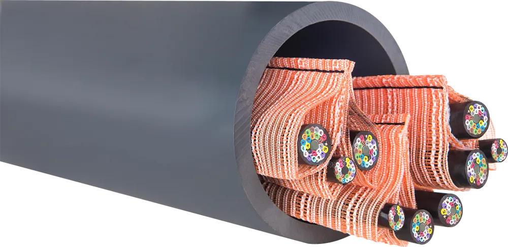
Dura-Line’s FuturePath consists of seven individual MicroDucts bundled under one over-sheath, allowing a single conduit to carry multiple pathways - enough to handle today’s connectivity demand while providing the scalability to meet future needs. Installation was made by a combination of vibratory ploughing and horizontal directional drilling, both common underground installation techniques.

The Ohio Smart Mobility Corridor links will allow premier automotive testing, research and manufacturing facilities to test smart transportation technologies on a highway that carriers up to 50,000 vehicles per day through rural and urban settings in a full range of weather conditions.

This data will also provide more frequent and accurate traffic counts, weather and surface condition monitoring and incident management improvements.

Booth 747

For more information on companies in this article

Related Content

  • Public transport operators implement passenger safety systems
    December 4, 2012
    Operators of public transport systems are arming themselves with sophisticated systems of technology to ward off terrorism threats to passenger safety. David Crawford reports. City transportation authorities worldwide are looking more keenly than ever for mass transit solutions to overcome traffic congestion and manage commuter flows. As they do so, concerns over passenger security are driving development of new technologies for terrorist incident detection, response and emergency passenger evacuation. The
  • Conduit intelligence for smart transportation
    July 25, 2025

    Let’s face it, existing roads, bridges and traffic systems weren’t designed for digital retrofitting. Trenching and boring through roads and pavements is disruptive, labour-intensive and expensive. As communication cabling needs surge across ITS corridors, the ability to easily maximise conduit space, minimise disruption, and future-proof networks becomes essential.

  • Traffic to flow freely over world’s widest bridge
    November 13, 2012
    Pete Goldin reports on a new Egis project in Canada, providing open road tolling operations for the widest bridge in the world. A bridge can present a bottleneck in a system of roads or it can support the smooth and unobstructed flow of traffic. Much depends on the bridge design, surrounding infrastructure and tolling system. By adding lanes and deploying open road tolling (ORT), the new Port Mann Bridge located in the metropolitan Vancouver area in British Columbia, will alleviate congestion at one of the
  • On a WIM – a global view of weigh in motion
    May 25, 2016
    Q-Free’s Andrew Lees looks at regional characteristics and technology trends in the global Weigh-In-Motion market. The principles of Weigh-In-Motion (WIM) are well established. Data derived from vehicles passing over in-ground sensors can be interpreted for vehicle classification (axle counts and spacing) and positive identification (especially when linked to image capture) applications as well as to derive individual axle and gross vehicle weight (GVW).