AI-InfraSolutions and Stemmer go the full 360°

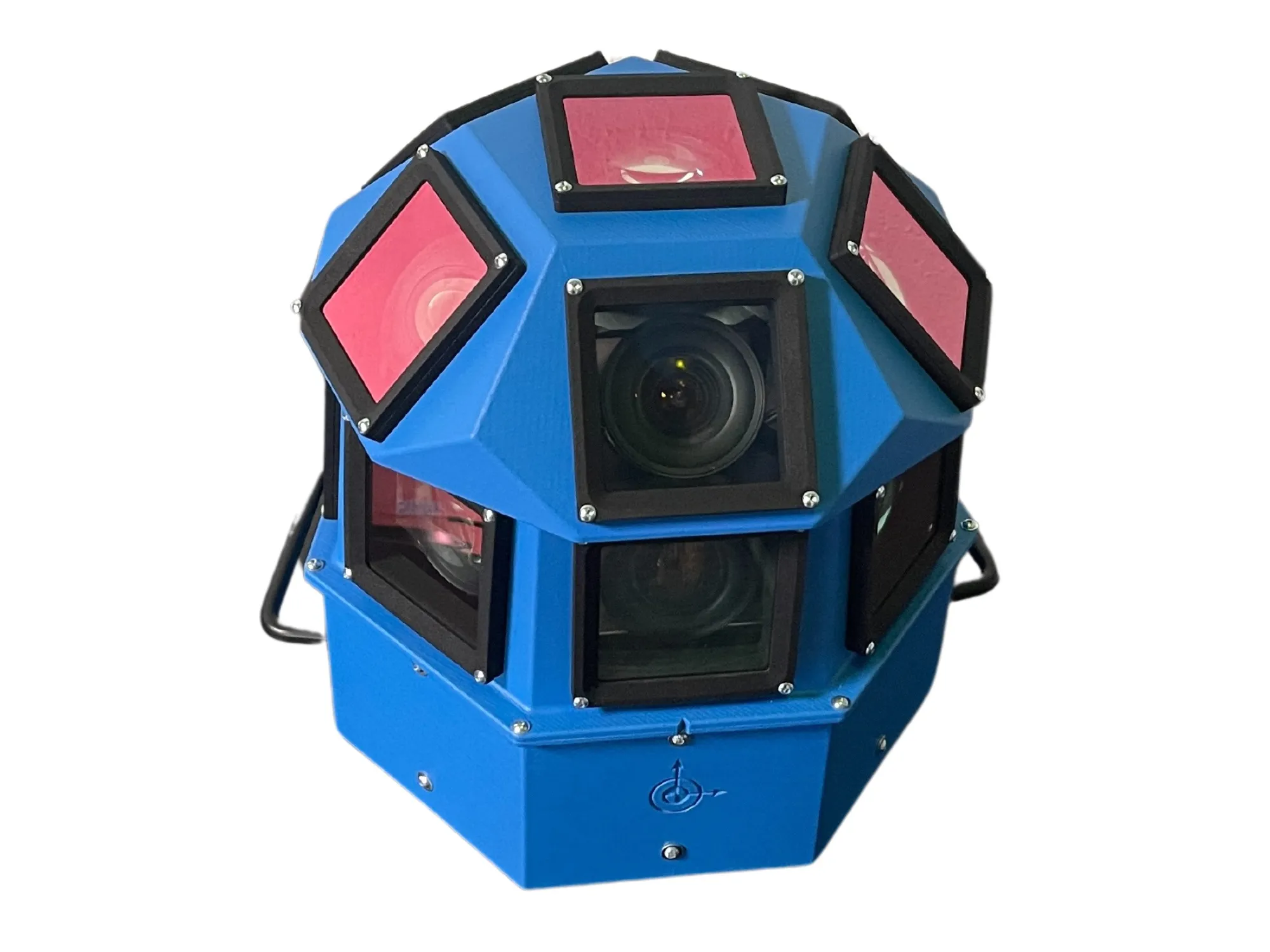
Panoramic camera head designed for automated data collection in traffic applications
By David Arminas November 13, 2024 Read time: 2 mins
The head delivers 180 MPixel resolution with 360° horizontal and 120° vertical coverage

AI-InfraSolutions, a geospatial mapping technology business, has partnered with Stemmer Imaging to develop a 360°-degree panoramic camera head.

It is designed for automated data collection in applications such as traffic sign identification, road condition assessments and environmental monitoring. The technology enables municipalities and companies to efficiently manage assets and adopt predictive maintenance strategies.

AI-InfraSolutions said the new head will “redefine the future of geospatial mapping”. Engineered through machine vision specialist Stemmer’s More Engineering Services, the head delivers 180 MPixel resolution with 360° horizontal and 120° vertical coverage. It captures synchronised images every 5m at driving speeds of up to 100km/h, making it an ideal solution for large-scale geospatial mapping projects.

Development of the head posed several technical challenges, including selecting optimal sensors, synchronising image capture with GNSS systems and minimising parallax for smooth panoramic stitching. Stemmer's engineering expertise and precise intrinsic calibration were instrumental in addressing these challenges. This resulted in a robust solution capable of continuous high-speed recording for up to 247km, expandable to 496km.

Once the images are captured, AI-InfraSolutions’ powerful AI-driven data processing algorithms automatically prepare the data for further analysis. This system is particularly effective in areas such as infrastructure asset management and road condition monitoring. Offline post-processing features, including tone mapping and panoramic stitching, ensure that the collected data is refined for optimal accuracy

“By combining our innovative approach with Stemmer Imaging’s leading vision, we are elevating our solutions to an unmatched level,” said Jeroen Zanen, founder and chief executive of AI-InfraSolutions.

Related Content

  • June 11, 2015
    Transportation applications move to machine vision’s mainstream
    The adaptation of machine vision to transport applications continues apace. That the machine vision industry is taking traffic installations seriously is evident by the amount of hardware and software products tailor-made for ITS applications that are now available on the market. A good example comes from US-based Gridsmart Technologies which has developed a single wire fisheye camera that provides a horizon to horizon view for use at intersections. Not only does the single camera replace four or more in a
  • January 31, 2012
    Wireless traffic data in real time
    The effect of moving objects on the electromagnetic landscape set up by cellular telephony networks can be detected and interpreted to give real-time traffic data across large geographical areas at low cost. Here, we revisit the Celldar concept. Global economic downturn has pushed public-sector agencies, transport administrations among them, to push even harder for cost efficiencies. Unfortunately, when it comes to transport safety and efficiency the public sector often has to work up to a cost rather than
  • May 29, 2014
    The role of GIS in climate change resiliency
    Climate change will pose global and local challenges and that includes risks to the transportation infrastructure. Climate change adaptation and resiliency has captured the attention of the transportation community for some time now. Because transportation infrastructure is often designed to last for 30, 50, or 100 years or even longer, transportation professionals are concerned not only about the impact on our existing investments, but also how to design more durable transportation systems for the future
  • August 30, 2023
    Lanternn by Valerann uses power of Big Data
    Product continuously processes data streams to deliver 100% road monitoring coverage