
Ford and StreetLight Data combine on safety  

Collision data and travel patterns are overlaid to see where road improvements are needed
By Adam Hill October 16, 2020 Read time: 2 mins
Bike, pedestrian and vehicle safety issues can be tackled, the two firms say (© Monopoly Monopoly | Dreamstime.com)

Ford Mobility and StreetLight Data have launched a data package which they say offers insights into road safety for departments of transportation and local authorities.

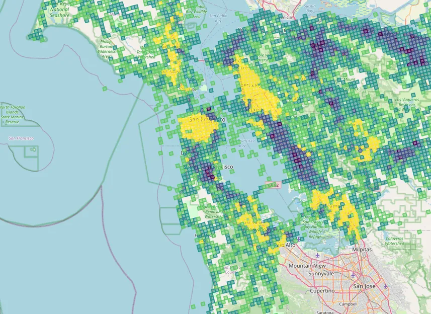
Safety Solutions brings together Ford’s Safety Insights tool - which uses collision data and connected vehicle input on near misses to find potential accident hotspots – and StreetLight’s Software as a Service (SaaS) platform StreetLight InSight, which supplies travel pattern data based on smartphones and navigation devices in connected vehicles, trucks and Internet of Things devices.

The new bundle can overlay crash information with vehicle, bicycle and pedestrian metrics to work out in which locations authorities should act to improve traffic safety.

“This kind of collation and analysis was previously very time-consuming and often lacked any visual representation to help planners and engineers rapidly identify, analyse and recommend countermeasures for particular safety concerns,” says Cal Coplai, product owner of Ford Mobility’s Safety Insights.

In a separate announcement, StreetLight’s data analysis has revealed that Covid-19 has changed traffic patterns in the US, shifting the morning rush hour in particular. 

Instead of the typical sharp increase in morning travel, followed by a drop and then an afternoon peak, the vehicle miles travelled (VMT) analysis shows weekday traffic building gradually toward a more sustained afternoon high.

In cities there are still ‘peak PM’ commutes – but the peaks are less pronounced.

Washington, DC, now has a slightly earlier peak for PM travel than during the same period in 2019, while Los Angeles and San Francisco have a “mini rush hour” just after lunch.

PM congestion begins earlier - but ends sooner – and there is more vehicle travel around midday than was the case last year.

Related Content

  • StreetLight brings transportation intelligence to EV planning
    April 11, 2023
    The electric vehicle (EV) revolution promises to reduce transportation emissions dramatically, create a new market, and change driving habits. But only if public agencies, chargpoint operators, and commercial properties locate their chargers in places where people will actually use them. As StreetLight will demonstrate to visitors, its transportation intelligence for EV infrastructure ensures that operators can place chargers based on critical driving behaviours.
  • StreetLight shines light on transport in underserved communities
    January 15, 2025
    Toolkit aims to help better serve disadvantaged urban areas with transport
  • Inrix identifies the worst traffic hotspots in the 25 most congested US cities
    September 28, 2017
    Inrix has published its latest research on the worst traffic hotspots in America. Using Inrix Roadway Analytics, a cloud-based traffic analysis tool, Inrix analysed and ranked more than 100,000 traffic hotspots in the 25 most congested US cities. The economic cost of hotspots was also calculated in terms of wasted time, lost fuel and carbon emissions over the next decade. The research identified and ranked 108,000 traffic hotspots in the 25 most congested cities in the US identified by the INRIX Global T
  • Big Data: Losing our way
    May 30, 2025
    Beate Kubitz finds missing information means the dream of safe and accurate trip planning and travel is not being fully realised – and asks how gaps can be plugged