Here unveils 3D road models for ADAS and driver safety

Here Technologies has launched Here Lanes with the aim of increasing driver awareness and road safety through advanced driver assistance systems (ADAS).
By Ben Spencer January 21, 2020 Read time: 1 min
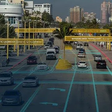
Here Lanes ADAS was launched at CES 2020 (source: Here Technologies)

Here Lanes is a digital representation of the global road network that enables a vehicle to position itself while providing drivers with lane-level visual guidance, the company adds. 

Sheila Nedelcu, head of automated driving at Here, said at CES 2020 in Las Vegas: “Here Lanes delivers automakers and software developers the data they need to improve today’s ADAS functions in all weather conditions while building the next generation of applications supported by lane-level positioning, guidance and visualisation.”  

Here Lanes is expected to feed ADAS and mobile applications with precise lane topology, geometry and attribute data such as the rules of the road, vehicle height restrictions, lane count and centre line, direction of travel and the slope and curvature of intersections. 


For more information on companies in this article

Related Content

  • Minnesota roads could go electric
    April 26, 2022
    Transportation infrastructure can evolve to support clean vehicle electrification, study finds
  • UK-invented tyre monitoring technology unveiled at ‘highway of the future’
    December 22, 2016
    A UK-developed technology that measures the tread depth and pressure of tyres in seconds, has been unveiled as part of a ground-breaking ‘highway of the future’ live project in the USA. Able to monitor the tyre condition without the need for any equipment or sensors on the vehicle itself, the road-embedded technology has been developed by WheelRight, an Oxford-based company. The drive-over technology has been adopted by The Ray, an 18 mile stretch of highway connecting Georgia and Alabama, which aims to
  • 5G-Safe project developing road weather services based on vehicle data
    April 21, 2017
    VTT Technical Research Centre of Finland is coordinating the 5G-Safe project, which is part of Tekes’ Challenge Finland competition. It is focused on the identification of local weather and road conditions on the basis of data collected from vehicles, and the sending of warnings to road users. In addition, real-time video and radar data will be exchanged between passing vehicles. Other issues being investigated include the use of data on local road weather conditions to improve the situational awareness of
  • Topcon mapping system
    February 6, 2012
    Topcon Positioning Systems (TPS) has announced an addition to its offering of high-accuracy, mobile mapping solutions. The IP-S2 HD Mapping System is a vehicle-mounted surveying and mapping system featuring a high-definition LiDAR scanner from Velodyne Lidar.