StreetLight Data provides free VMT metrics

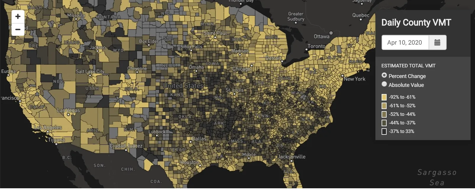
StreetLight Data is offering vehicle miles travelled (VMT) data for US transit agencies to monitor transport networks and understand travel patterns during the Covid-19 pandemic.
By Adam Hill April 17, 2020 Read time: 2 mins
StreetLight Data maps VMT across the US

There has been massive disruption to travel patterns since February and Streetlight’s information covers more than 3,100 counties across the US, updated three times a week.

Designed to measure the transportation impact on communities, it is free to planners, researchers and engineers, as well as federal, state and local governments.

"Transportation professionals make critical budget and planning projections based on gas tax revenue and other factors derived from VMT,” explains CEO Laura Schewel.

“The recent massive drop in travel is throwing off all those plans. This data-driven map gets the key metrics out quickly, with local granularity, to those who need them. Planners, like everyone else, are adjusting to a new reality and we’re here to help navigate it. We hope this, in some way, can help our transportation community in this difficult and unprecedented time."

Location intelligence provider Cuebiq is working with StreetLight, and has developed what it calls a ‘near-real time’ mobility index to improve the outbreak forecast and response.

“StreetLight fused Cuebiq’s index with its own algorithms that transform GPS data into contextualised, aggregated and normalised travel patterns, as well as its deep repositories of data depicting historical VMT,” the company said in a statement.

The data is available here.

For more information on companies in this article

Related Content

  • Nokia announcement is game changer for global navigation industry
    June 6, 2012
    Nokia has announced plans to release a new version of Ovi Maps for its smartphones that includes high-end walk and drive navigation at no extra cost, available for download at www.nokia.com/maps. This move has the potential to nearly double the size of the current mobile navigation market.The new version of Ovi Maps includes high-end car and pedestrian navigation features, such as turn-by-turn voice guidance for 74 countries, in 46 languages, and traffic information for more than 10 countries, as well as de
  • Joined-up thinking for future ITS
    May 8, 2015
    David Crawford looks at a US model which, for modest federal funding, is producing substantive results. Outward and upward is the clear message emerging from the US$458,000, 2015 workplan of the US government’s ENTERPRISE (Evaluating New TEchnologies for Roads PRogram Initiatives in Safety and Efficiency) joint funding scheme for ITS research.
  • IBTTA 2010 meeting focuses on sustainability
    February 2, 2012
    Ken Philmus, chief meeting organiser, talks about what attendees can expect to see at this year's IBTTA annual meeting and exhibition
  • New technology revolution in urban traffic control?
    January 26, 2012
    Urban traffic control is a well-defined and practised art. Nevertheless, there are technologies here and on the horizon with the potential to revolutionise how we do things. By Gavin Jackman and Andrew Kirkham, TRL, and Jason Barnes. Distributed monitoring and control of urban traffic networks and flows is nothing new. PC-based Urban Traffic Control (UTC) is now well established and operating in many locations around the world. However, it is worth considering the effects of the huge growth in the use of sm