
PTV partners with 3D VR specialist Forum8 

Idea is to create more realistic pictures of traffic networks for urban planning
By Adam Hill June 11, 2020 Read time: 1 min
Forum8's VR realisations are imported into PTV Vissim (image courtesy PTV Group)

PTV Group has partnered with 3D virtual reality (VR) software specialist Forum8 to create clearer simulations of road environments.

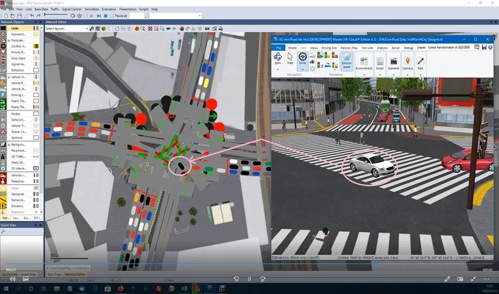
Forum8's photo-realistic software, VR-Design Studio, is already used by transport planners and will now be paired with PTV's own traffic simulation solution, Vissim.

VR Design Studio creates models which can be imported into PTV Vissim in real time, creating a clear picture of vehicles and traffic signals so that simulated traffic patterns can be accurately visualised.

“The availability of the VR Design Studio API significantly enhances the functionality of PTV Vissim and enables mobility and transport consultants to present all stakeholders with a traffic impact assessment in an interactive 3D VR representation of their built environment,” said Forum8 western general manager Brendan Hafferty.

The companies say the combination "will also help cities, companies and communities save time and money, enhance road safety and minimise the impact on the environment of noise pollution and CO2 emissions".

“This is a major and growing requirement across the world as cities and countries work towards improving the problem of traffic congestion as well as meeting their decarbonisation targets," Hafferty adds.

PTV product manager Jochen Lohmiller comments: “Decision makers expect realistic visualisations of future infrastructure changes."

For more information on companies in this article

Related Content

  • US Cities push for smarter poles
    June 25, 2018
    US Cities The need to connect existing infrastructure has led various US transit authorities into imaginative alleyways: David Crawford examines some new roles for street furniture. US cities are vying with each other in developing schemes to create a new generation of connected places. Their strategies include taking advantage of their streetlight poles’ height and ubiquity to give them new roles in supporting intelligent nodes. They are now being equipped for collecting real-time data on key transport
  • Jeddah juggles transport needs of residents, pilgrims and tourists
    December 22, 2015
    Mass pilgrimages, new tourists and a growing population lead Jeddah to seek some smart transport solutions as David Crawford finds out. Rationalising traffic movement and public transport in a major Middle Eastern business and tourist centre that is also a gateway for millions of religious pilgrims every year is the challenge for the 20-year Jeddah Strategic Plan and the Jeddah Public Transport Programme (JPTP) it spawned. The latter is costed at US$8bn.
  • Smart parking technologies: solving drivers parking pain
    March 30, 2017
    Smarter parking can benefit city authorities and other road users as well as drivers looking for a space, argues Dr Graham Cookson. As witnessed by the recent announcements at the Consumer Electronics Show, the automotive industry continues to focus on the driving experience; moving from speed and handling towards safety and efficiency.
  • Reducing congestion with Tomtom's historical traffic data
    December 5, 2012
    Historical traffic data provided by TomTom is being used by the local government in Spain’s Basque region to reduce road congestion at less cost. Old habits die hard. Photos from as far back as the 1930s show people counting cars by the roadside in order to provide congestion data to those running road networks. Today, such techniques are still used, albeit augmented by a range of automation technologies such as inductive loops, infra-red sensors and number plate recognition. Even with these advances, howe