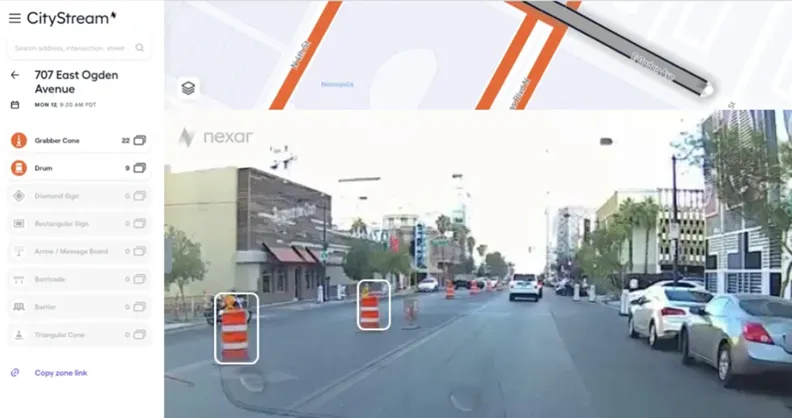
Nexar is to provide US transit agencies, cities and Departments of Transportations (DoT) access to a service that detects, monitors and maps road work zones.
The dash cam company says all images are then accurately located for context and time and then sent over to city officials.
Government plans to rebuild infrastructure, including fixing 20,000 miles of roads and 10,000 bridges across the US, are expected to create a sharp increase in new work zones causing traffic congestion and safety challenges.
As infrastructure restoration picks up speed, Nexar insists its CityStream licence allows users to know how many work zones there are at any given time.
According to Near, the data will preserve the road’s vehicle capacity and coordinate activities in order to eliminate the danger of open trenches, close proximity of pedestrians to roadways or immovable objects on the road.
Nexar collects data every month from 130 million miles and has a dataset of 3.2 trillion images. The company is now extending its capabilities to the transportation industry because work zones are generally unreported to mapping services.
The platform detects barricade elements in work zones using artificial intelligence and imagery from its dash cam network, remotely monitors the state of all work zones in real-time and enforces the safety of pedestrians, workers and drivers, the company adds.
Nexar co-founder Eran Shir says: “As a result of Covid-19, traffic patterns have become even more dynamic, which means valuable time is wasted optimising safety and moderating traffic congestion in work zones.”
“Nexar enables cities to go back in time and check work zone setups on-demand instead of being supported by old data or out-of-date plans, thus ensuring that cities and DoTs are addressing today’s transportation patterns. Using Nexar’s data to address this issue means benefiting workers on the road, governmental decision makers and the community itself.”
As part of the initiative, the service is available for three months at no cost to government offices.
Those interested in Nexar's programme can apply here.