Utah intersection Lidar traffic management from Seoul Robotics

Firm says signals at Salt Lake City installation are first to be Lidar-controlled in US
By Adam Hill July 8, 2024 Read time: 2 mins
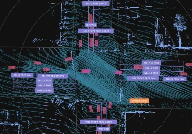
Lidar sensors are at each corner of the intersection, and create a digital twin (image: Seoul Robotics)

Seoul Robotics has deployed its Lidar-powered traffic signal system in Utah, US.

Installed at the junction of State Street and 5900 South in Murray, Salt Lake City, this is the first intersection in the US where traffic signals are controlled directly by Lidar technology, Seoul Robotics says.

The Utah Department of Transportation (UDoT) wanted advanced sensor technology that can detect, count and track vehicles and other road users under any weather conditions. 

The installation is powered by Seoul Robotics' 3D Perception engine, housed in a compact edge device, with Lidar sensors at each corner of the intersection, which create a digital twin which feeds data to optimise traffic flow and reduces congestion.

Local distributor Gades Sales Company has ensured the system is integrated into local infrastructure, while Blue Band's software translates the data from the 3D Perception Engine into signal commands compatible with existing traffic controllers. 

Seoul Robotics says the solution "mounts directly onto existing infrastructure without significant road work and infrastructure changes". 

Traffic management features include precise stop-bar detection, advanced vehicle detection up to 300 feet from the stop bar, and red-light running. The system has a vehicle counting accuracy of 99.8% at the stop bar, the firm says.

 "Since its installation, our Lidar-based traffic management system has consistently demonstrated excellent detection and tracking of objects, ensuring reliable performance across all weather conditions," says Lee Han-bin, CEO of Seoul Robotics.

"This technology not only meets but exceeds the demands of modern traffic systems."

As well as vehicle flow, the system is designed to accurately count and monitor vulnerable road users, such as pedestrians and cyclists at crosswalks and kerbsides.

Seoul Robotics says deep learning and 3D computer vision ensure that all perceived objects are accurately tracked and classified in real time, enhancing safety and traffic flow across multiple road user types.

For more information on companies in this article

Related Content

  • Topcon mapping system
    February 6, 2012
    Topcon Positioning Systems (TPS) has announced an addition to its offering of high-accuracy, mobile mapping solutions. The IP-S2 HD Mapping System is a vehicle-mounted surveying and mapping system featuring a high-definition LiDAR scanner from Velodyne Lidar.
  • Citilog’s incident detection sees through storms, enhances road safety
    March 11, 2024
    As many as 30% of road crashes across Europe are weather related, underscoring the challenges faced by traffic operators and drivers alike. When skies turn stormy, highways, bridges, and tunnels become particularly treacherous, with higher speeds, limited visibility, and specific structural hazards amplifying the dangers.
  • Migrating to advanced traffic management systems
    March 14, 2012
    Rich pickings of reduced cost and greater value are up for grabs as highway authorities migrate to new traffic management systems – if they choose their paths wisely. Jon Masters reports. Experience gained and expertise developed over the past decade are informing good advice for transport agencies contemplating new or expanded traffic management systems. Technological projects aimed at reducing road congestion may be frequently unique and invariably complex, but a picture is emerging of sensible, prudent a
  • Iteris launches computer vision for smarter crosswalks
    August 12, 2016
    Iteris has added new pedestrian measurement capabilities to its advanced video detection platforms with PedTrax, which it says automates measurement of the count, direction and speed of pedestrians in crosswalks to provide insights on levels of street life. PedTrax provides transportation professionals and officials with data on foot traffic volume, direction and speed to optimise intersection signal timing and inform proactive improvements to signage and striping, intersection design, overpass locations