TomTom and Esri fusion transform urban mobility

April 28, 2025 Read time: 2 mins

A collaboration between TomTom and Esri will take centre stage at the upcoming Congress with a session titled "Driving Insights: Unlocking the Power of TomTom Historic Traffic Data in ArcGIS.” Led by industry experts Frans Keijzer from TomTom and Jaime Nieves from Esri Spain, this presentation will showcase how integrating TomTom's historical traffic data with the ArcGIS platform has transformed urban mobility in Gran Canaria, Spain.

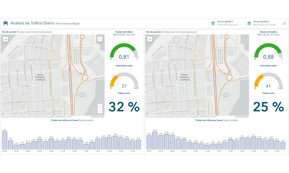
The initiative, spearheaded by Esri Spain and Sagulpa, sought to create a digital twin of the urban area to enhance planning and management. By leveraging TomTom's robust traffic data and using ArcGIS, the team swiftly deployed interactive maps and applications without extensive IT support. Key tools included TomTom Traffic Stats and TomTom Origin-Destination for traffic analysis and ArcGIS Dashboards and ArcGIS Experience Builder for dynamic visualizations.

This session (on Tuesday 20 May 20 from 11.45 to 12.45 in Hall Madrid D) will showcase the significant potential of TomTom Move data when combined with ArcGIS, making it an essential tool for those interested in advancing urban mobility solutions. Attendees will learn about three main applications derived from this initiative: a safety dashboard for monitoring traffic flow, a public transportation and emergency response planning tool, and an event traffic analysis application for managing large-scale events like football matches. These tools provide decision-makers with valuable insights, leading to improved traffic safety and optimised transportation routes.

Related Content

  • Nokia powers future of highways – one network at a time
    April 28, 2025


    Cutting-edge ITS technologies are exciting — with their potential for delivering safer, more sustainable and efficient highway travel. But they don’t operate in isolation. To perform at their best, they need a mission-critical communications network with outstanding capabilities, supporting connectivity from the roadside spanning the wide area to the data centre.

  • ITF Corporate Partnership Board projects highlight ways forward
    October 29, 2014
    The findings of the first four projects launched by the ITF Corporate Partnership Board (CPB), the organisation's platform for engaging with the private sector, have been announced. CPB projects are designed to enrich policy discussion with a business perspective. They are launched in areas where CPB member companies identify an emerging issue in transport policy or an innovation challenge to the transport system. Led by ITF, work is carried out in collaborative fashion in working groups consisting of CP
  • New name offers new solutions
    November 26, 2013
    Pete Goldin examines Nokia’s rationale for combining its location services, digital mapping and other capabilities under the HERE brand. While it has divested itself of its mobile phone business to Microsoft, Nokia has kept hold of its HERE business unit and brand which incorporates the company’s location services with digital mapping and other capabilities. The creation of HERE is much more than rebranding as its services are heading off the map and into the cloud. “HERE offers the first location cloud
  • Cellint measures speed and travel time without roadside infrastructure
    April 10, 2014
    Collecting speed and travel time data without using roadside infrastructure could offer new possibilities to cash-strapped road authorities. Streaming video may be useful for traffic controllers to monitor incidents and automatic number plate recognition may be required for enforcement, but neither are necessary for many ITS functions. For instance travel times, tailbacks, percentage of vehicles turning, origin and destination analysis can all be done using Bluetooth and/or WI-Fi sensors and without video o