TomTom and Esri fusion transform urban mobility

April 28, 2025 Read time: 2 mins

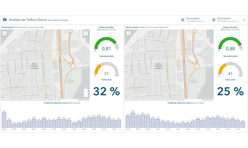
A collaboration between TomTom and Esri will take centre stage at the upcoming Congress with a session titled "Driving Insights: Unlocking the Power of TomTom Historic Traffic Data in ArcGIS.” Led by industry experts Frans Keijzer from TomTom and Jaime Nieves from Esri Spain, this presentation will showcase how integrating TomTom's historical traffic data with the ArcGIS platform has transformed urban mobility in Gran Canaria, Spain.

The initiative, spearheaded by Esri Spain and Sagulpa, sought to create a digital twin of the urban area to enhance planning and management. By leveraging TomTom's robust traffic data and using ArcGIS, the team swiftly deployed interactive maps and applications without extensive IT support. Key tools included TomTom Traffic Stats and TomTom Origin-Destination for traffic analysis and ArcGIS Dashboards and ArcGIS Experience Builder for dynamic visualizations.

This session (on Tuesday 20 May 20 from 11.45 to 12.45 in Hall Madrid D) will showcase the significant potential of TomTom Move data when combined with ArcGIS, making it an essential tool for those interested in advancing urban mobility solutions. Attendees will learn about three main applications derived from this initiative: a safety dashboard for monitoring traffic flow, a public transportation and emergency response planning tool, and an event traffic analysis application for managing large-scale events like football matches. These tools provide decision-makers with valuable insights, leading to improved traffic safety and optimised transportation routes.

Related Content

  • A touch of reality as Flow Labs unveils digital twin platform
    April 23, 2024
    Flow RT is a cutting-edge real-time digital twin platform designed to provide agencies with minute-by-minute data on traffic conditions, signal operations and roadway incidents. According to Flow Labs, Flow RT removes uncertainty from traffic management by delivering accurate insights at lightning-fast speed.
  • Toll performance exceeds expectations, improves travel times
    January 30, 2012
    Jean Harito, Attica Tollway Operations Authority and Steve Morello, Egis Projects describe how looking to exceed contractual obligations makes good operational and business sense. The Attica Tollway is a modern, 65km, access-controlled urban motorway with three lanes in each direction. It constitutes the ring road around the extensive metropolitan area of the Greek capital, Athens, and forms the backbone of the entire road network in the Attica region. By ensuring freeflow operating conditions, the Attica T
  • Cubic and MasterCard launch Urbanomics Mobility Project
    September 16, 2015
    Cubic Transportation Systems (CTS) and its subsidiary Urban Insights are to collaborate with MasterCard on the Urbanomics Mobility Project, a new data analysis platform to fuel smarter, more inclusive cities. The initiative leverages Urban Insights’ state-of-the-art big data analytics and visualisation technology; Cubic’s expertise in processing more than US$24 billion per year in public transportation revenue; and powerful spending trends and insights derived from 43 billion transactions processed over
  • TomTom delivers data in Esri format
    March 22, 2012
    TomTom has announced the availability of its MultiNet suite of map products in Esri’s file geodatabase format. Large TomTom datasets may now be consumed directly by Esri applications in a file geodatabase format that is configurable within the customer’s environment, saving time and effort for GIS professionals. The geodatabase format enables Esri users to utilise their TomTom data within multiuser access and editing environments for desktop, server and mobile environments.