TomTom and Esri fusion transform urban mobility

April 28, 2025 Read time: 2 mins

A collaboration between TomTom and Esri will take centre stage at the upcoming Congress with a session titled "Driving Insights: Unlocking the Power of TomTom Historic Traffic Data in ArcGIS.” Led by industry experts Frans Keijzer from TomTom and Jaime Nieves from Esri Spain, this presentation will showcase how integrating TomTom's historical traffic data with the ArcGIS platform has transformed urban mobility in Gran Canaria, Spain.

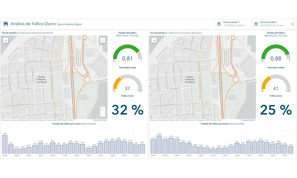
The initiative, spearheaded by Esri Spain and Sagulpa, sought to create a digital twin of the urban area to enhance planning and management. By leveraging TomTom's robust traffic data and using ArcGIS, the team swiftly deployed interactive maps and applications without extensive IT support. Key tools included TomTom Traffic Stats and TomTom Origin-Destination for traffic analysis and ArcGIS Dashboards and ArcGIS Experience Builder for dynamic visualizations.

This session (on Tuesday 20 May 20 from 11.45 to 12.45 in Hall Madrid D) will showcase the significant potential of TomTom Move data when combined with ArcGIS, making it an essential tool for those interested in advancing urban mobility solutions. Attendees will learn about three main applications derived from this initiative: a safety dashboard for monitoring traffic flow, a public transportation and emergency response planning tool, and an event traffic analysis application for managing large-scale events like football matches. These tools provide decision-makers with valuable insights, leading to improved traffic safety and optimised transportation routes.

For more information on companies in this article

Related Content

  • Connected vehicle trials get big backing from USDOT
    March 14, 2016
    Connected vehicle technology will emerge as a sustainable reality at three sites in the US over the next four years. Jon Masters reports. Advocates of connected vehicle (CV) technology have received a welcome boost from news that the US government has committed a further $4 billion towards automated vehicle research and CV technology. This comes hot on the heels of the US Department of Transportation’s $42 million CV pilot pledge in October last year.
  • Arkansas opts for ClearPath winter weather forecasting
    November 11, 2014
    The Arkansas State Highway and Transportation Department (AHTD) has selected Iteris’ cloud-based maintenance decision support system (MDSS), ClearPath Weather, to provide state-wide weather forecasting services for improved winter road maintenance response. ClearPath Weather will provide AHTD with web-based access to high-resolution pavement weather forecasting and treatment alternatives at designated locations around the state during winter weather events. Additionally, AHTD will have available use of I
  • Priority boosts ridership and cuts congestion
    May 4, 2016
    Transit priority is proving a win-win in Europe and Australia. David Crawford reports. Technology that integrates with the Australian-originated Sydney Coordinated Adaptive Traffic System (SCATS) is driving bus signal priority and performance analysis initiatives on both sides of the world; in its homeland, with a major deployment in 2015, and in the capital of the Republic of Ireland.
  • Here to provide VIA with traffic data
    February 3, 2016
    Mapping and location technology provider Here is to provide traffic software specialists VIA with historical and current traffic data that will enable VIA to enhance the quality of services it provides to government customers. Under a commercial agreement between the two companies, Netherlands-based VIA will utilise Here’s Traffic Analytics, a service that helps enterprises and government customers make informed decisions about future traffic flow management. Traffic Analytics offers access to a vast qua