
TomTom and Esri fusion transform urban mobility

April 28, 2025 Read time: 2 mins

A collaboration between TomTom and Esri will take centre stage at the upcoming Congress with a session titled "Driving Insights: Unlocking the Power of TomTom Historic Traffic Data in ArcGIS.” Led by industry experts Frans Keijzer from TomTom and Jaime Nieves from Esri Spain, this presentation will showcase how integrating TomTom's historical traffic data with the ArcGIS platform has transformed urban mobility in Gran Canaria, Spain.

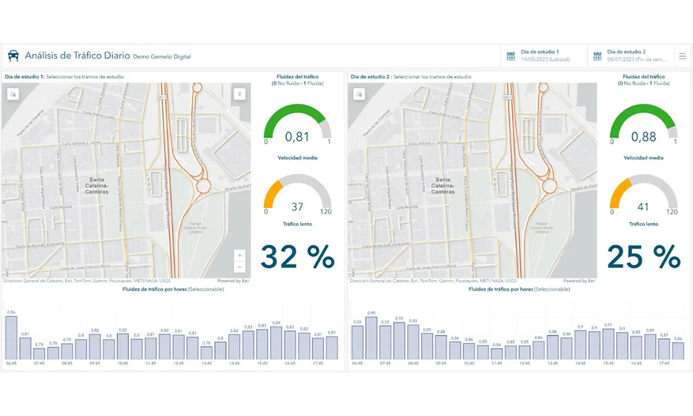
The initiative, spearheaded by Esri Spain and Sagulpa, sought to create a digital twin of the urban area to enhance planning and management. By leveraging TomTom's robust traffic data and using ArcGIS, the team swiftly deployed interactive maps and applications without extensive IT support. Key tools included TomTom Traffic Stats and TomTom Origin-Destination for traffic analysis and ArcGIS Dashboards and ArcGIS Experience Builder for dynamic visualizations.

This session (on Tuesday 20 May 20 from 11.45 to 12.45 in Hall Madrid D) will showcase the significant potential of TomTom Move data when combined with ArcGIS, making it an essential tool for those interested in advancing urban mobility solutions. Attendees will learn about three main applications derived from this initiative: a safety dashboard for monitoring traffic flow, a public transportation and emergency response planning tool, and an event traffic analysis application for managing large-scale events like football matches. These tools provide decision-makers with valuable insights, leading to improved traffic safety and optimised transportation routes.

For more information on companies in this article

Related Content

  • Transport data service goes Dutch
    January 28, 2021
    New national platform will enable authorities in Netherlands to improve traffic flow
  • Urban tunnel replaces viaduct, improves safety
    October 10, 2012
    Earthquake sensors, automatic barriers and real time monitoring systems are all part of a scheme to make a major Seattle traffic artery safer, by taking it underground. Huw Williams reports. Seattle’s metropolitan area of 3.5 million people, like much of the western seaboard of the United States, lies in an earthquake zone. In Seattle’s case, the city and its hinterland sit atop a complex network of interrelated active geological faults capable of severe seismic activity and posing complex considerations fo
  • ITS European Congress 2023: ‘It’s about mobility’
    May 15, 2023
    ITS European Congress 2023 in Lisbon will deliberately focus on a broad range of transport modes. Joost Vantomme and Lisa Boch-Andersen from organiser Ertico explain why
  • DataCollect will unveil two groundbreaking products
    March 19, 2024
    As anticipation builds for Intertraffic Amsterdam, Germany-headquartered DataCollect Traffic Systems is looking forward to unveiling of not one, but two groundbreaking products it says are poised to redefine the landscape of traffic management and urban mobility. These innovations represent a convergence of cutting-edge technology and real-world application, promising to address critical challenges in transportation infrastructure.