
Theia develops innovative distortion-free ultra-wide-angle lenses

Today’s high-resolution cameras have many advantages if they have the right lens for the job. When that includes covering large areas or reducing cost by installing fewer cameras, you need a wide-angle lens. Fisheye style lenses with barrel distortion are routinely used to cover an ultra-wide field of view; however, they create a curved and distorted image which causes significant loss of resolution at the image edges. This presents a variety of issues for ITS applications such as difficulty in identification or recognition of objects and details.
October 26, 2022 Read time: 2 mins


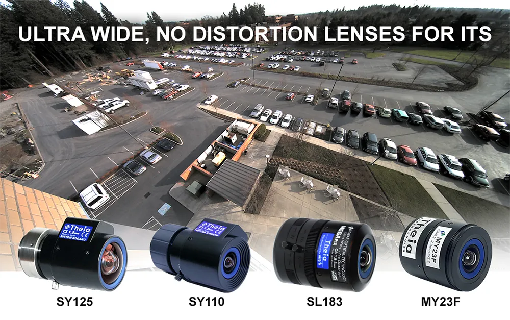
To counter the drawbacks of fisheye-style optics, Theia Technologies has developed a suite of rectilinear lenses offering a different, ultra-wide field of view without the barrel distortion or loss of edge resolution characteristic of fisheye style lenses. Theia achieves this optically, without the use of image correction software or its inherent latency.

The company employs its patented Linear Optical Technology to create a family of multi-megapixel lenses that offer horizontal fields of view up to 135 degrees with very low distortion while improving the resolution at the image edge compared to typical wide-angle lenses.

Applications for Theia’s family of ultra-wide, low distortion lenses include providing great peripheral vision for situational awareness in navigation and remote operation of vehicles and robots used in a variety of ITS applications from logistics to assisted and unmanned vehicles. They capture wide areas at short distances such as in under-vehicle surveillance and shipping container identification, among many other imaging tasks, including applications in close-up applications such as ATMs, card-locked garage entries, and multi-door entryways where both high image detail and wide fields of view are required. Other applications for Theia’s family of ultra-wide, low-distortion lenses include effectively monitoring large areas like parking lots, multi-lane tolling stations, and warehouses.

Choosing the right lens for an application depends on many factors including field of view, required image resolution, multi-spectral capability, image format and mount, among others. To assist in lens selection, Theia offers an image resolution simulator and lens calculator that relates FOV, resolution, and object distance.

Visitors to the Theia website will find it also offers other tools and white papers for a better understanding of its lens technology and selection of the optimal lens for your application.

Content produced in association with Theia Technologies

For more information on companies in this article

Related Content

  • Videology adds camera board to help users see in the dark
    January 11, 2018
    Videology has added another extended SDI camera board to its latest range of cameras designed for traffic monitoring, surveillance and other non-traffic functions. Designated the 24RS2.0.XWEXSDI, it can transmit 1080P HD images up to 300m (1,000ft). The camera board is designed to obtain images beyond the human eye without near-IR LED illumination, which can also be used if required. Colour noise is reduced and colour brightness is enhanced. Sony Starvis’ sensor captures the available photon beyond near-IR
  • Q-Free sees logic in video tolling
    September 15, 2014
    Q-Free’s Frank Kjelsli talks to Colin Sowman about why video tolling could be the boost to efficiency and interoperability the industry is seeking. Like it or not, the principal of one person, one tolling account is likely to become a reality: be that in America with the 2016 interoperability deadline or the European EETS requirement. Multi-tag readers are being introduced and alliances are being formed to meet legislative requirements but as the debate continues about which systems and protocols to adopt,
  • LiDAR sets its sights on future problems
    February 23, 2017
    AAdvances in LiDAR are helping transport authorities improve services and identify potential problem areas, as geospatial technology expert Dr Neil Slatcher explains. The effects of climate change on the transport infrastructure have long been a cause of concern within the transportation sector - and not only on the structures themselves but also on the surrounding areas. This year, those concerns have become reality with landslides, structural collapses and surfacing issues impacting services across the wo
  • Data clears the road, says TomTom
    July 11, 2025
    Technology is one of the main tools in cutting congestion quickly and effectively. But it can’t just be about making things better for car drivers, explains TomTom’s Andy Marchant…