
Seyond and TrafficSensors partner in Australasia

Collaboration will bring ITS management platform to Australia and NZ
By David Arminas March 28, 2025 Read time: 2 mins
Light Horse Interchange in NSW, Australia at the junction of the M4 Western Motorway and the Westlink M7 (© Steven Tritton | Dreamstime.com)

Seyond, a provider of Lidar solutions, has partnered with TrafficSensors.Com, an ITS supplier, installer and maintainer in Australia and New Zealand.

The collaboration will bring the Seyond ITS management platform (SIMPL) to the two countries where TrafficSensors has been installing and maintaining advanced traffic systems for 40 years and has thousands of sensors and systems deployed.

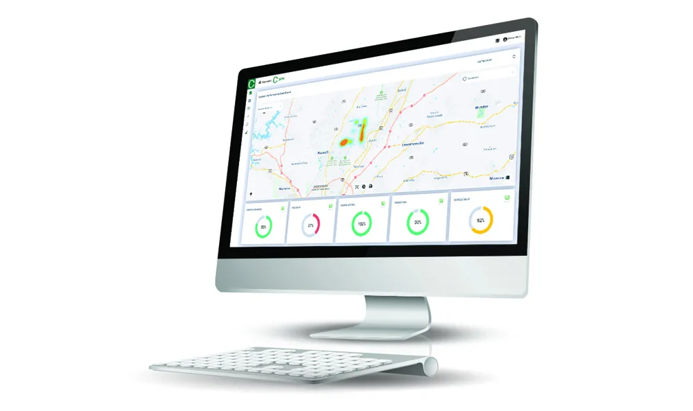
Seyond’s SIMPL solutions for intersection and highway combine its long-range, high-resolution Falcon Lidar sensors and advanced traffic perception software.

The company said that, with an ultra-long range of over 500m and exceptional accuracy in all weather and lighting conditions, the Falcon K sensor delivers high-fidelity data with exceptional resolution and flexibility for precise object detection and tracking.

Combined with Seyond’s traffic perception software powered by an edge processor, SIMPL provides comprehensive and high-precision road user perception and event detection. It detects and classifies all road users, including pedestrians and cyclists, without collecting any biometric data. 

The system can also track their trajectories and provide detailed data on counts, speed, size and safety, allowing municipalities and transportation authorities to make data-driven decisions for optimised traffic flow, reduced congestion and improved safety.

“Partnering with Seyond allows us to deliver next-generation intelligent transportation systems to our clients," said Jamie Mann, director of TrafficSensors. “Seyond’s powerful Lidar and SIMPL complements our longstanding commitment to excellence in traffic solutions.”

TrafficSensors' reputation and expertise in traffic systems "make them an ideal partner to help us enhance traffic safety and efficiency across the region",  said Philip Lasner, global head of global ITS business at Seyond. 

Seyond and TrafficSensors plan to work closely with local governments, transportation agencies and private stakeholders for seamless integration and scalability of SIMPL.

For more information on companies in this article

Related Content

  • Chubb launches new camera system for smart motorways
    August 8, 2017
    Chubb Systems has launched a television outstation (TVOS) and an all-weather traffic monitoring CCTV camera system that it says delivers the high quality images demanded by smart motorways. The unit comprises a long-range, high-resolution camera with optical zoom and back light compensation, an infrared array with 500m range, and a television base unit (TVBU). The system’s infrared array enables the TVOS to deliver images in zero light conditions to monitor traffic flow and motorway incidents as well as inc
  • Econolite raises the innovation bar by introducing Centracs Mobility
    September 4, 2020
    Econolite introduces Centracs Mobility, a highly flexible cloud-based software solution platform, designed to provide added value and actionable information, augmenting the traffic management software toolset. The new software solution combines all the proven capabilities of Centracs Advanced Transportation Management System (ATMS) currently deployed in over 325 agencies in North America, with the cloud-based data analytics of signal performance measures (SPM), signal timing optimisation, and real-time signal control.
  • Tritium scales up EV charging
    January 12, 2021
    Company's platform means 50kW DC chargers can be upgraded to 75kW and beyond
  • TrafiOne the focal point for Flir Systems at Intertraffic
    April 4, 2016
    Flir Systems is using Intertraffic to launch the Flir TrafiOne Smart City Sensor, an all-round detection sensor for traffic monitoring and dynamic traffic signal control. Offered in a compact and easy-to-install package, the device uses thermal imaging and Wi-Fi tracking technology to provide traffic engineers with high-resolution data on vehicles, bicycles and pedestrians at intersections and in urban environments.