Moovit helps guide visually-impaired transit riders

Moovit has partnered with remote assistance app Aira and Microsoft Azure Maps to help make public transit more accessible for blind and low-vision riders.
January 14, 2020 Read time: 1 min
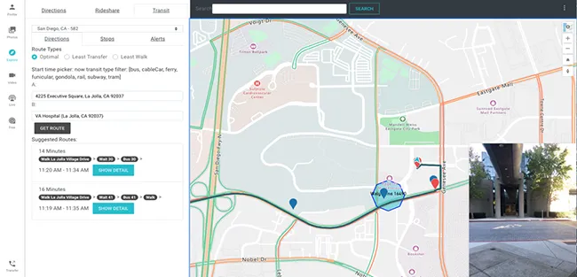
Moovit says Aira’s mobile app or smart glasses allow Aira agents to see a user’s environment through their smartphone camera. This partnership is expected to assist agents in helping users navigate public transit more effectively, with better real-time data.

Azure Maps will provide agents with access to navigational tools while Moovit’s transit application programming interfaces will offer information on multimodal trip planning and transit routes, the company adds.

Yovav Meydad, Moovit’s chief growth and marketing officer, says the solution will “open opportunities for riders to travel more freely and independently, significantly impacting their life”.

Related Content

  • Masabi provides contactless ticketing system for Bilbobus riders
    November 19, 2018
    Masabi has added contactless EMV ticketing capabilities to its Justride platform in the city of Bilbao, Spain. The technology will allow commuters travelling on Bilbobus vehicles to pay for fares via contactless bank cards. The company says fare collection is enabled via a cloud-based system which reduces the cost of running and maintaining IT infrastructure. Also, the system can be configured to meet specific fare and policy requirements such as entitlements, fare capping and best fare finding.
  • ITS needs data highways
    November 18, 2014
    Transport and traffic data is on the increase but there must be an integrated data highway to derive the maximum ITS benefits, argues Deutsche Telekom. From public transport operators recording increasingly precise and comprehensive data on their vehicle’s position and driving behaviour to local authorities using RFID and video systems to control traffic on their streets and highways, the amount of traffic data is growing rapidly.
  • The role of GIS in climate change resiliency
    May 29, 2014
    Climate change will pose global and local challenges and that includes risks to the transportation infrastructure. Climate change adaptation and resiliency has captured the attention of the transportation community for some time now. Because transportation infrastructure is often designed to last for 30, 50, or 100 years or even longer, transportation professionals are concerned not only about the impact on our existing investments, but also how to design more durable transportation systems for the future
  • Iteris & Otonomo 'unlock mobility infrastructure'
    January 25, 2023
    Connected vehicle data will be shared by companies to improve traffic intelligence