Moovit helps guide visually-impaired transit riders

Moovit has partnered with remote assistance app Aira and Microsoft Azure Maps to help make public transit more accessible for blind and low-vision riders.
January 14, 2020 Read time: 1 min
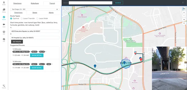
Moovit says Aira’s mobile app or smart glasses allow Aira agents to see a user’s environment through their smartphone camera. This partnership is expected to assist agents in helping users navigate public transit more effectively, with better real-time data.

Azure Maps will provide agents with access to navigational tools while Moovit’s transit application programming interfaces will offer information on multimodal trip planning and transit routes, the company adds.

Yovav Meydad, Moovit’s chief growth and marketing officer, says the solution will “open opportunities for riders to travel more freely and independently, significantly impacting their life”.

Related Content

  • December 5, 2018
    C/AVs & smart cities: a symbiotic relationship, says WSP
    C/AVs and smart cities are still in their infancy. But Mike Warren suggests thatintegrating their data and services can create a co-operative relationship that improves safety, liveability and the economy for citizens The recent technological boom has led to two major public advances: connected and automated vehicles (C/AVs) and smart cities. While these are significant in their own right, when coupled together they create a new way in which citizens can access city services; live in safer, environment
  • June 4, 2015
    Multi-modal’s long road into the transportation mainstream
    Andrew Bardin Williams looks at 20 years of multimodal transport in the Sun Belt and beyond and the key requirement for user engagement. Phoenix residents will head to the polls in August to decide whether to implement a three-tenths of a cent sales tax to fund the city’s new multimodal transportation plan. It will be the second transportation-related sales tax hike in the past 15 years yet city officials and advocates expect the resolution to easily pass—despite the strong anti-tax environment that has dom
  • November 24, 2017
    City of Toronto and Waze share traffic data to help motorists navigate the City
    The City of Toronto has formed a partnership with community-based traffic and navigation app Waze which will provide both companies with free access to each other’s real-time traffic and road data, providing motorists with information on how to navigate the area. It will also allow the City to use anonymous Waze driver and traffic insights to make data-driven infrastructure decisions. Waze will help the City to disseminate traffic and road closure information for major events, highway maintenance and
  • January 26, 2012
    Bringing V2I and V2V communications to workzone safety
    Imran Hayee of the University of Minnesota Duluth's Department of Electrical and Computer Engineering talks about efforts to bring V2I and V2V communications into work zones. With USDOT backing and under the auspices of the ITS Joint Program Office Connected Vehicle Research (formerly IntelliDrive) research programme, M. Imran Hayee of the University of Minnesota Duluth's Department of Electrical and Computer Engineering along with team of his students, have been conducting research into the application of