Moovit helps guide visually-impaired transit riders

Moovit has partnered with remote assistance app Aira and Microsoft Azure Maps to help make public transit more accessible for blind and low-vision riders.
January 14, 2020 Read time: 1 min
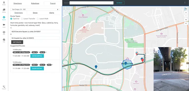
Moovit says Aira’s mobile app or smart glasses allow Aira agents to see a user’s environment through their smartphone camera. This partnership is expected to assist agents in helping users navigate public transit more effectively, with better real-time data.

Azure Maps will provide agents with access to navigational tools while Moovit’s transit application programming interfaces will offer information on multimodal trip planning and transit routes, the company adds.

Yovav Meydad, Moovit’s chief growth and marketing officer, says the solution will “open opportunities for riders to travel more freely and independently, significantly impacting their life”.

Related Content

  • UK drivers get real time traffic information boost
    August 9, 2012
    The UK Highways Agency is trialling a system to add commercially available traffic data to its existing sources to monitor how well traffic is flowing on England's motorways and strategic roads. Similar data sources are already used by satellite navigation devices, smartphones, and applications like Google maps. Better real-time data will allow agency staff to respond more quickly to incidents and identify delays and communicate them to drivers so they can take alternative routes if necessary.
  • IntelliDrive, connectivity, safety, mobility and the environment?
    January 30, 2012
    Shelley Row, Director of the ITS Joint Program Office, US Department of Transportation, details the new five-year ITS Strategic Research Plan. Imagine a world where vehicles of all types can talk to each other in order to reduce or eliminate crashes, where vehicles can talk to traffic signals to eliminate unnecessary stops, where travellers can get accurate travel time information about all modes and route options, and where transportation managers have data which allows them to accurately assess multimodal
  • How ITS can help world out of lockdown
    June 2, 2020
    Ticketing, reallocation of street space, transport’s place in urban ecosystems – it's all up for grabs as we emerge from pandemic
  • Los Angeles pilots new travel planning app
    January 27, 2016
    The City of Los Angeles is piloting a new transportation app in partnership with Xerox in an effort to provide travellers with optimised transportation choices to simplify urban mobility in the second largest metro area in the US. The Go LA app aggregates and calculates the time, cost, carbon footprint and health benefits from walking, cycling, driving your own car, parking, taking public transit, as well the emerging private transportation options, such as Lyft, Zipcar, FlitWays and Uber, giving users a