Esri helps UDOT consolidate maps into single platform

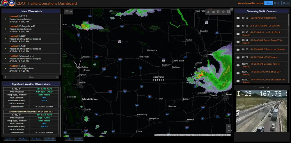
Utah Department of Transportation (UDOT) has launched a new website that consolidates hundreds of traffic and infrastructure maps on a single platform, following an open government initiative touted by the state. “Utah views transportation infrastructure as the property of its citizens,” said Terry Bills, global transportation industry manager for Esri. “They paid the bills. They should be able to access this type of information.
September 10, 2014 Read time: 2 mins
ITSWC 2014 Master Avatar

Utah Department of Transportation (UDOT) has launched a new website that consolidates hundreds of traffic and infrastructure maps on a single platform, following an open government initiative touted by the state.

“Utah views transportation infrastructure as the property of its citizens,” said Terry Bills, global transportation industry manager for 50 Esri. “They paid the bills. They should be able to access this type of information.” 

Built by Esri, the website allows drivers and citizens to view more than 1,000 layers of information from roadside barriers and medians to traffic incident statistics. Users can then drill down to view individual assets–giving them both a holistic view of the state’s transportation infrastructure as well as detailed information going on in their individual neighbourhoods and streets.

One of the most popular feeds is the Safety Index, a map and repository of traffic incidents for every street in the state. Users can see the number of accidents on a particular stretch of roadway, the accident rate and whether any injuries or fatalities have occurred.

The website is also used internally at the DOT, providing valuable information for the state’s traffic management engineers and repair crews. Critical infrastructure information can be called up a worker’s laptop in the field, giving them an accurate catalogue of the asset in question as they pull up. The information is routed to the TOC where engineers can make informed decisions based on real-time events.

“TOCs have standard operating procedures when dealing with events. We can automate those processes for them and tell them what’s really going on,” Bills said.

Visit uplan.maps.arcgis.com to access the UDOT information.

 www.esri.com

Related Content

  • October 22, 2012
    The Institute of Engineering and Technology discusses future UK rollout of Low Carbon Vehicles
    Delegates to the ITS World Congress will have a superb opportunity of getting to know the Institution of Engineering and Technology (IET), Europe’s largest professional society of engineers and technicians with over 150,000 members in 127 countries around the world. The organisation is holding a drinks reception on Wednesday from 16.30 on Stand D71 (the ITS UK stand) during which delegates will be able to find out about the latest developments from the IET Transport Sector that provides a focal point to acc
  • September 7, 2020
    Esri highlights benefits of a state-wide data-rich environment
    Walk into virtually any traffic operations centre and you will be confronted by people flipping between different screens and CCTV monitors, and individually viewing a large number of stand-alone applications to try to understand a comprehensive picture of their live traffic, weather, incident, and snow conditions from these disparate sources.
  • September 10, 2014
    Meet RideScout
    A new mobile app called RideScout provides Transit as a Service (TaaS) by consolidating multiple public, private and social transit options in a single platform.
  • September 8, 2014
    Marben shows V2X successes at World Congress
    Marben Products is here at the ITS World Congress flushed with major successes achieved this year. The US NHTSA connected vehicle decision and the French government Scoop@F initiative (3,000 vehicles and 2,000 km of roads equipped with V2X) are new significant steps towards the large scale deployment of the Vehicle-to-Vehicle and Vehicle-to-Infrastructure (V2X) communication technology.