Blyncsy produces US interstate highway asset map

Data from more than one million vehicles is available to US DoTs
By David Arminas November 7, 2024 Read time: 2 mins
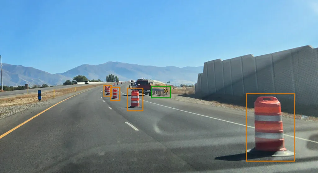
Map is created using crowd-sourced dash camera imagery (image: Blyncsy)

Blyncsy says it has mapped all US interstate highways showing assets such as guardrails, speed limit signs and work zones to support safety and maintenance work.

The Bentley Systems company has made the data available to all US state departments of transportation. 

The map is created using crowd-sourced dash camera imagery from more than one million vehicles in use today. When coupled with Blyncsy’s artificial intelligence image analysis toolset, 40 different road conditions and asset inventory issues in near-real time are detected. These issues include potential roadway safety hazards, from guardrail damage, missing signage and lack of proper road striping to roadway vulnerabilities from crashes, natural disasters and work zone areas.

“With increasing workloads and smaller budgets, state DoTs need a way to improve roadway safety and operational efficiencies,” said Mark Pittman, chief executive of Blyncsy and Bentley’s director of transportation AI. 

“Today, we’re supporting a national digital infrastructure vision and democratising roadway data by publishing an open dataset of US highways to help state DoTs better prepare, maintain and repair more miles and create safer environments for maintenance crews and drivers.”

Blyncsy’s AI-powered crowd-sourced data is delivered through an open API (application programming interface). The company says that it provides state DoTs with a solution that is infinitely scalable and is more cost-efficient compared to other manual data collection technologies, including Lidar and traditional road inspection methods which require onsite road maintenance crews.

"The application of advanced technologies like AI, combined with new sources of data, are transforming the transportation sector, giving us better information as we make investments in safety and mobility,” said Laura Chace, president and chief executive of ITS America.

"We applaud companies like Blyncsy for deploying these forward-thinking technologies and making this digital infrastructure data available to the public in an accessible format.”

The map is available through Blyncsy’s website.

Among the company’s clients are Hawaii DoT, North Central Texas Council of Governments and the Port Authority of New York and New Jersey.

For more information on companies in this article

Related Content

  • TomTom and Baidu join forces to develop HD maps for autonomous driving
    July 7, 2017
    TomTom and Chinese mapping service provider Baidu have joined forces to develop high definition (HD) maps for autonomous driving.
  • US enforcement regulation to deliver clearer guidelines?
    February 2, 2012
    Jim Tuton of American Traffic Solutions looks at the evolution of automated enforcement in North America "Technological regulation will become more sophisticated at the federal level, giving states clearer guidelines" Jim Tuton In just 20 years, photo enforcement in North America has grown from a single speed camera in a small town in Arizona to thousands of photo traffic enforcement cameras which are now operating in 350 communities spread across 27 states and three Canadian provinces. Most of these p
  • US adopts automated enforcement… gradually
    March 4, 2014
    The US automated enforcement market is in rude health as the number of systems and applications continues to grow and broaden. Jason Barnes reports. Blessed and cursed – arguably, in equal measure – with a constitution which stresses the right to self-expression and determination, the US has had a harder journey than most to the more widespread use of automated traffic enforcement systems. In some cases, opposition to the concept has been extreme – including the murder of a roadside civil enforcement offici
  • Savings accrue from on-line from truck screening
    October 18, 2013
    An online truck pre-clearance system is allowing enforcement to be better targeted towards offending vehicles. Utah is the latest US State department of transportation (DOT) to deploy HELP (Heavy Vehicle Electronic License Plate) Inc’s new 360SmartView electronic truck screening and sorting system at vehicle inspection sites to speed up compliance checks. The initial locations will be at Perry on Interstate 15 (I-15), which were the first sites in the state to implement HELP’s PrePass transponder-based v