Blyncsy produces US interstate highway asset map

Data from more than one million vehicles is available to US DoTs
By David Arminas November 7, 2024 Read time: 2 mins
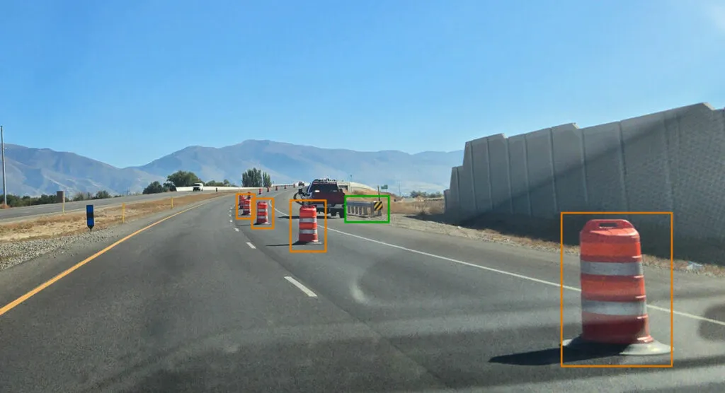
Map is created using crowd-sourced dash camera imagery (image: Blyncsy)

Blyncsy says it has mapped all US interstate highways showing assets such as guardrails, speed limit signs and work zones to support safety and maintenance work.

The Bentley Systems company has made the data available to all US state departments of transportation. 

The map is created using crowd-sourced dash camera imagery from more than one million vehicles in use today. When coupled with Blyncsy’s artificial intelligence image analysis toolset, 40 different road conditions and asset inventory issues in near-real time are detected. These issues include potential roadway safety hazards, from guardrail damage, missing signage and lack of proper road striping to roadway vulnerabilities from crashes, natural disasters and work zone areas.

“With increasing workloads and smaller budgets, state DoTs need a way to improve roadway safety and operational efficiencies,” said Mark Pittman, chief executive of Blyncsy and Bentley’s director of transportation AI. 

“Today, we’re supporting a national digital infrastructure vision and democratising roadway data by publishing an open dataset of US highways to help state DoTs better prepare, maintain and repair more miles and create safer environments for maintenance crews and drivers.”

Blyncsy’s AI-powered crowd-sourced data is delivered through an open API (application programming interface). The company says that it provides state DoTs with a solution that is infinitely scalable and is more cost-efficient compared to other manual data collection technologies, including Lidar and traditional road inspection methods which require onsite road maintenance crews.

"The application of advanced technologies like AI, combined with new sources of data, are transforming the transportation sector, giving us better information as we make investments in safety and mobility,” said Laura Chace, president and chief executive of ITS America.

"We applaud companies like Blyncsy for deploying these forward-thinking technologies and making this digital infrastructure data available to the public in an accessible format.”

The map is available through Blyncsy’s website.

Among the company’s clients are Hawaii DoT, North Central Texas Council of Governments and the Port Authority of New York and New Jersey.

For more information on companies in this article

Related Content

  • Michigan fosters real-world testing of workzone ITS
    September 19, 2017
    Turning a ‘problem’ into ‘an opportunity’ is the mantra of just about every business book and Michigan Department of Transportation (MDoT) looks set to achieve that aim in Oakland County, where 29km (18 miles) of the I-75 needs to be reconstructed. Running north-northwest from Detroit, the I-75 carries around 170,000 vehicles per day but, being built in the 1970s, it now requires an additional lane in each direction and upgrading to the latest design and safety standards. Upgrading will be carried out in
  • Priority for safety and interoperability, need for DSRC
    July 18, 2012
    Justin McNew, Chief Technology Officer, Kapsch TrafficCom Inc., USA offers his opinion of where 5.9GHz DSRC technology will head in the coming years. The debate ranges back and forth over the most suitable technological solution for future tolling and charging in the US. However, the coming trend is common cooperative infrastructure: instrumented roads and vehicles with the capacity to communicate with each other over all manner of safety, mobility and traveller applications, many of which will involve fina
  • Communications redundancy increases VMS reliability
    December 17, 2014
    Hybrid communications to variable message signs increase resilience to natural disasters and enable deployment in remote areas, as Alan Allegretto explains. Variable Message Signs (VMSs) are a common sight and a well-proven means to improve public safety on our roads and highways. ITS professionals rank the VMS as second only to interoperable radios as the most important technology to improve effectiveness during emergency incidents and evacuations. Ironically, however, current systems suffer from one criti
  • Jim Zemlin spells out the Linux links to ‘The Infrastructure of Things’
    June 14, 2016
    Jim Zemlin, executive director of The Linux Foundation, will take center stage at ITS America 2016 San Jose on Tuesday, June 14, 2016, at 10:00 am as the keynote speaker for today’s theme: “The Infrastructure of Things.” We’re thrilled Jim will be sharing his vision of how open source collaboration initiatives will drive the future of intelligent transportation,” said Regina Hopper, president and CEO of the ITS America.