Blyncsy produces US interstate highway asset map

Data from more than one million vehicles is available to US DoTs
By David Arminas November 7, 2024 Read time: 2 mins
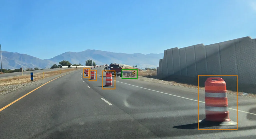
Map is created using crowd-sourced dash camera imagery (image: Blyncsy)

Blyncsy says it has mapped all US interstate highways showing assets such as guardrails, speed limit signs and work zones to support safety and maintenance work.

The Bentley Systems company has made the data available to all US state departments of transportation. 

The map is created using crowd-sourced dash camera imagery from more than one million vehicles in use today. When coupled with Blyncsy’s artificial intelligence image analysis toolset, 40 different road conditions and asset inventory issues in near-real time are detected. These issues include potential roadway safety hazards, from guardrail damage, missing signage and lack of proper road striping to roadway vulnerabilities from crashes, natural disasters and work zone areas.

“With increasing workloads and smaller budgets, state DoTs need a way to improve roadway safety and operational efficiencies,” said Mark Pittman, chief executive of Blyncsy and Bentley’s director of transportation AI. 

“Today, we’re supporting a national digital infrastructure vision and democratising roadway data by publishing an open dataset of US highways to help state DoTs better prepare, maintain and repair more miles and create safer environments for maintenance crews and drivers.”

Blyncsy’s AI-powered crowd-sourced data is delivered through an open API (application programming interface). The company says that it provides state DoTs with a solution that is infinitely scalable and is more cost-efficient compared to other manual data collection technologies, including Lidar and traditional road inspection methods which require onsite road maintenance crews.

"The application of advanced technologies like AI, combined with new sources of data, are transforming the transportation sector, giving us better information as we make investments in safety and mobility,” said Laura Chace, president and chief executive of ITS America.

"We applaud companies like Blyncsy for deploying these forward-thinking technologies and making this digital infrastructure data available to the public in an accessible format.”

The map is available through Blyncsy’s website.

Among the company’s clients are Hawaii DoT, North Central Texas Council of Governments and the Port Authority of New York and New Jersey.

For more information on companies in this article

Related Content

  • Here’s HD AV map prepared for 5G
    June 17, 2019
    The emergence of 5G may not be necessary to provide a high-definition map for autonomous driving, says Matt Preyss from Here Technologies. Ben Spencer asks why 5G is a hot topic worldwide, with the potential for faster transfer of information eagerly awaited by those convinced that it will be a game-changer for the ITS industry. High-definition (HD) maps are essential to allow autonomous vehicles (AVs) to understand their environment, and operate safely within it in relation to other road users and p
  • TxDOT unveils high tech workzone warning system
    May 3, 2013
    With more roadway construction underway than ever in the state, the Texas Department of Transportation (TxDOT) is introducing its first highway safety feature that incorporates a queue warning system and temporary rumble strips to reduce work-zone collisions. Making its debut along a central Texas stretch of I-35, the system uses sensors to measure the speeds of approaching vehicles and then warns drivers through portable, electronic signs about upcoming traffic backups due to night lane closures in work zo
  • IBTTA calls on Congress to repeal regulation on tolling interstate highways
    May 24, 2017
    The White House has released President Trump’s fiscal year 2018 budget, including a US$200 billion investment in infrastructure projects over the next 10 years with a focus on leveraging the power of public private partnerships. The International Bridge, Tunnel and Turnpike Association (IBTTA) has responded, saying the government should repeal the burden of regulation and give states maximum flexibility to use financing tools to meet their local needs. 35 states and territories throughout the country have u
  • Missouri’s Road to Tomorrow provides ITS answers
    December 22, 2015
    Andrew Bardin Williams looks at Missouri’s plans to become America’s ITS testbed The state of Missouri launched its Road to Tomorrow initiative earlier this summer at the ITS America Annual Meeting and Expo in Pittsburgh, rolling out the welcome mat for transportation officials to try out new, innovative ITS technologies in the field.