Blyncsy produces US interstate highway asset map

Data from more than one million vehicles is available to US DoTs
By David Arminas November 7, 2024 Read time: 2 mins
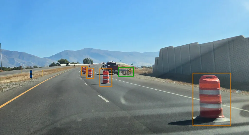
Map is created using crowd-sourced dash camera imagery (image: Blyncsy)

Blyncsy says it has mapped all US interstate highways showing assets such as guardrails, speed limit signs and work zones to support safety and maintenance work.

The Bentley Systems company has made the data available to all US state departments of transportation. 

The map is created using crowd-sourced dash camera imagery from more than one million vehicles in use today. When coupled with Blyncsy’s artificial intelligence image analysis toolset, 40 different road conditions and asset inventory issues in near-real time are detected. These issues include potential roadway safety hazards, from guardrail damage, missing signage and lack of proper road striping to roadway vulnerabilities from crashes, natural disasters and work zone areas.

“With increasing workloads and smaller budgets, state DoTs need a way to improve roadway safety and operational efficiencies,” said Mark Pittman, chief executive of Blyncsy and Bentley’s director of transportation AI. 

“Today, we’re supporting a national digital infrastructure vision and democratising roadway data by publishing an open dataset of US highways to help state DoTs better prepare, maintain and repair more miles and create safer environments for maintenance crews and drivers.”

Blyncsy’s AI-powered crowd-sourced data is delivered through an open API (application programming interface). The company says that it provides state DoTs with a solution that is infinitely scalable and is more cost-efficient compared to other manual data collection technologies, including Lidar and traditional road inspection methods which require onsite road maintenance crews.

"The application of advanced technologies like AI, combined with new sources of data, are transforming the transportation sector, giving us better information as we make investments in safety and mobility,” said Laura Chace, president and chief executive of ITS America.

"We applaud companies like Blyncsy for deploying these forward-thinking technologies and making this digital infrastructure data available to the public in an accessible format.”

The map is available through Blyncsy’s website.

Among the company’s clients are Hawaii DoT, North Central Texas Council of Governments and the Port Authority of New York and New Jersey.

Related Content

  • USDOT to fund New York, New Jersey transit systems upgrades
    September 23, 2014
    US Transportation Secretary Anthony Foxx has announced that 40 projects have been competitively selected to receive a share of US$3.59 billion in federal disaster relief funds to help public transportation systems in the areas affected by Hurricane Sandy to become more resilient, in order to withstand the impact of future natural disasters. Approximately 90 per cent of the funds will be invested in resilience projects primarily in New York and New Jersey, where transit systems sustained the worst of the
  • Vaisala's RoadAI can optimise maintenance
    August 20, 2019
    Alerts for natural disasters are ones that most of us would rather do without, writes Adam Hill. But the ITS industry still needs help to deal with more common meteorological issues Google Maps has added SOS alerts to its service. For those of us more used to using the phone app to navigate from a metro station to an unfamiliar restaurant, this may seem extreme. But this is not what Google has in mind. Its SOS messages are for “hurricane forecast cones, earthquake shake-maps and flood forecasts”. That
  • Public Private Partnerships to gather pace in the US
    April 29, 2015
    Public Private Partnerships are set to play a big role in transportation funding as Andrew Bardin Williams discovers. The old joke goes that the road from New York to Chicago is paved with potholes. For decades, drivers from New York and New Jersey traveling across Pennsylvania to visit the Midwest have lambasted the Commonwealth’s roadways for their lack of smooth pavement.
  • Dynamic Message Signs : Don’t replace, refurbish and upgrade
    August 12, 2015
    Refurbishing old dynamic message signs can save money and increase technical capabilities as David Crawford discovers. Evidence is growing on both sides of the Atlantic of the scope for retrofitting old or technically out-of-date dynamic message signs (DMS) with new electronic equipment, to save on the costs of installing full-scale replacements. In the last four months of 2014, a number of US states progressed programmes that achieved savings of more than US$1.75 million (€1.56million).