Blyncsy produces US interstate highway asset map

Data from more than one million vehicles is available to US DoTs
By David Arminas November 7, 2024 Read time: 2 mins
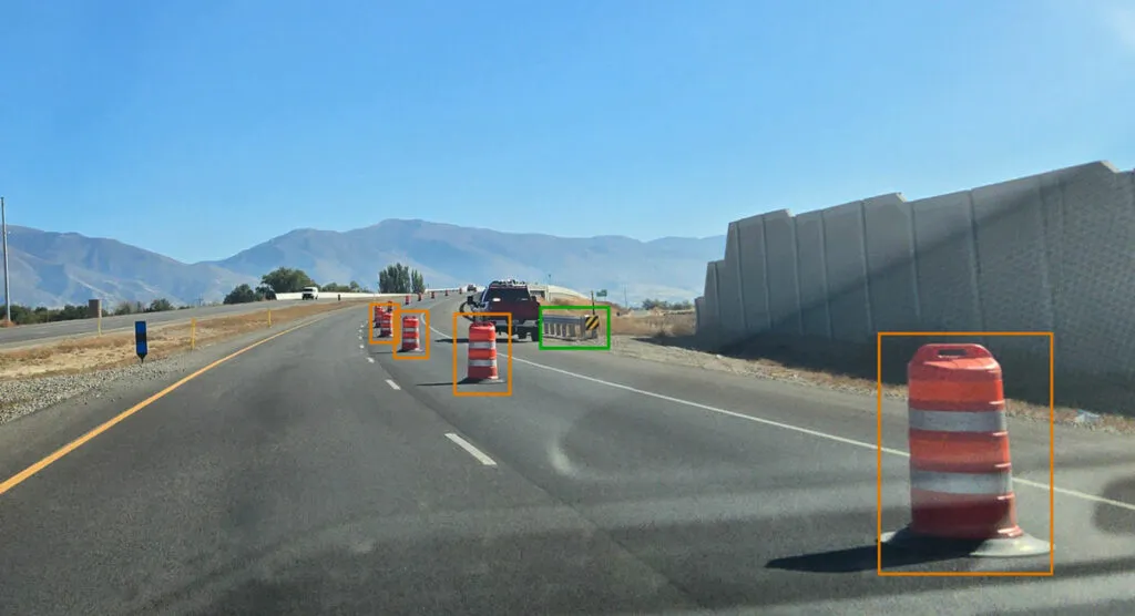
Map is created using crowd-sourced dash camera imagery (image: Blyncsy)

Blyncsy says it has mapped all US interstate highways showing assets such as guardrails, speed limit signs and work zones to support safety and maintenance work.

The Bentley Systems company has made the data available to all US state departments of transportation. 

The map is created using crowd-sourced dash camera imagery from more than one million vehicles in use today. When coupled with Blyncsy’s artificial intelligence image analysis toolset, 40 different road conditions and asset inventory issues in near-real time are detected. These issues include potential roadway safety hazards, from guardrail damage, missing signage and lack of proper road striping to roadway vulnerabilities from crashes, natural disasters and work zone areas.

“With increasing workloads and smaller budgets, state DoTs need a way to improve roadway safety and operational efficiencies,” said Mark Pittman, chief executive of Blyncsy and Bentley’s director of transportation AI. 

“Today, we’re supporting a national digital infrastructure vision and democratising roadway data by publishing an open dataset of US highways to help state DoTs better prepare, maintain and repair more miles and create safer environments for maintenance crews and drivers.”

Blyncsy’s AI-powered crowd-sourced data is delivered through an open API (application programming interface). The company says that it provides state DoTs with a solution that is infinitely scalable and is more cost-efficient compared to other manual data collection technologies, including Lidar and traditional road inspection methods which require onsite road maintenance crews.

"The application of advanced technologies like AI, combined with new sources of data, are transforming the transportation sector, giving us better information as we make investments in safety and mobility,” said Laura Chace, president and chief executive of ITS America.

"We applaud companies like Blyncsy for deploying these forward-thinking technologies and making this digital infrastructure data available to the public in an accessible format.”

The map is available through Blyncsy’s website.

Among the company’s clients are Hawaii DoT, North Central Texas Council of Governments and the Port Authority of New York and New Jersey.

For more information on companies in this article

Related Content

  • New York pioneers online mobile real-time bus tracking
    May 22, 2012
    An unusual technology collaboration. David Crawford investigates Early in January 2012, the New York City Metropolitan Transportation Authority (MTA) rolled out the first borough-wide implementation of its pioneering Bus Time online mobile real-time tracking service. The system allow commuters to track each bus on every route in real-time on the internet, via smartphones and by text messaging to a mobile phone. The MTA chose Staten Island for its first live launch due to it being the only one of the five Ne
  • Lindsay and Iteris to create smart workzones on US roads
    April 5, 2019
    Lindsay, a manufacturer of infrastructure equipment, has partnered with Iteris to create smart workzones on roads across the US. The partnership supports the Federal Highways Administration’s Smarter Work Zone campaign to reduce traffic congestion and improve safety in workzones using ITS solutions. Research suggests there were 799 workzone-related fatalities in the US in 2017 – a 4.5% rise from the previous three-year average of 764. Linday says its Road Zipper moveable barrier system is designe
  • Compromise possible on US transportation funding
    January 23, 2015
    Following President Obama’s State of the Union address, republicans are indicating that they are open to compromising with the president on increasing US transportation funding, although neither side has offered specifics on how they would pay for new construction projects. According to The Hill, Obama has called for Congress to pass a bipartisan infrastructure plan, including using savings from tax reform to pay for transportation projects, although he stopped short of calling for an increase in the fe
  • Highways England to trial wirelessly connected vehicles and driverless cars
    April 11, 2016
    Highways England (HE) is to invest US$213.5 million (£150 million) on new technology, including trials of driverless car technology on motorways. As part of its innovation strategy, HE may introduce a connected corridor, or ‘wi-fi road’, which could see cars and infrastructure wirelessly connected, with drivers receiving news of advanced road closures or congestion warnings. The strategy also includes trialling radar technology on motorways and in tunnels to improve the way breakdowns are detected. A