Blyncsy produces US interstate highway asset map

Data from more than one million vehicles is available to US DoTs
By David Arminas November 7, 2024 Read time: 2 mins
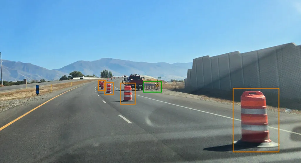
Map is created using crowd-sourced dash camera imagery (image: Blyncsy)

Blyncsy says it has mapped all US interstate highways showing assets such as guardrails, speed limit signs and work zones to support safety and maintenance work.

The Bentley Systems company has made the data available to all US state departments of transportation. 

The map is created using crowd-sourced dash camera imagery from more than one million vehicles in use today. When coupled with Blyncsy’s artificial intelligence image analysis toolset, 40 different road conditions and asset inventory issues in near-real time are detected. These issues include potential roadway safety hazards, from guardrail damage, missing signage and lack of proper road striping to roadway vulnerabilities from crashes, natural disasters and work zone areas.

“With increasing workloads and smaller budgets, state DoTs need a way to improve roadway safety and operational efficiencies,” said Mark Pittman, chief executive of Blyncsy and Bentley’s director of transportation AI. 

“Today, we’re supporting a national digital infrastructure vision and democratising roadway data by publishing an open dataset of US highways to help state DoTs better prepare, maintain and repair more miles and create safer environments for maintenance crews and drivers.”

Blyncsy’s AI-powered crowd-sourced data is delivered through an open API (application programming interface). The company says that it provides state DoTs with a solution that is infinitely scalable and is more cost-efficient compared to other manual data collection technologies, including Lidar and traditional road inspection methods which require onsite road maintenance crews.

"The application of advanced technologies like AI, combined with new sources of data, are transforming the transportation sector, giving us better information as we make investments in safety and mobility,” said Laura Chace, president and chief executive of ITS America.

"We applaud companies like Blyncsy for deploying these forward-thinking technologies and making this digital infrastructure data available to the public in an accessible format.”

The map is available through Blyncsy’s website.

Among the company’s clients are Hawaii DoT, North Central Texas Council of Governments and the Port Authority of New York and New Jersey.

For more information on companies in this article

Related Content

  • ITS advancement lays beyond benefit-cost analysis
    May 29, 2013
    Shelley Row, former Director of the US Department of Transportation’s ITS Joint Program Office, gives her views on the way forward for the industry. We, as intelligent transportation system (ITS) proponents and engineers, tend to be overly fixated on benefit-cost data. We want decisions to be made on logical grounds for which benefit-cost calculations are optimal. While benefit-cost data is necessary, it is not always sufficient. We can learn from our history where we see three broad groups of ITS deploymen
  • Reducing highways spend with Yotta DCL’s Horizons
    July 18, 2013
    London’s Southwark Council, with help from highway technology and survey company Yotta DCL is developing a comprehensive capital investment programme for network repairs and maintenance. Southwark will use Horizons, Yotta DCL’s web-based visualised asset management platform to target work schemes more precisely, resulting in better return on investment and improving its network. Southwark weights its network according to priorities to users. Using Horizons, the Council can identify and map the roads and pat
  • New solutions for catching texting drivers
    October 28, 2016
    Many countries have laws prohibiting texting while driving but enforcement is proving difficult – David Crawford looks at some new approaches being tried by authorities. Finding definitive solutions – technological, regulatory and educational - to the potentially lethal practice of people driving while using mobile phones is proving elusive, while the stakes grow higher.
  • Reauthorization 2012: the facts laid bare
    September 12, 2012
    A reauthorization bill for transportation came into law in July 2012, rubber stamping federal funding increases through the 2014 financial year, among other things. The new bill presents the good, the bad and the ugly of transportation infrastructure in the US, writes Pat Jones On June 29 this year, the US House of Representatives and Senate both approved the conference report on the ‘Moving Ahead for Progress in the 21st Century Act’ or MAP-21. President Obama signed this legislation into law on July 6.