Connected vehicle research and development is being aimed at improving driver safety and mobility, but is also promising advanced weather monitoring and warning systems. Sheldon Drobot reports.
Over the last few years, the United States’The utility of mobile vehicle data is especially valued for diagnosing road weather conditions. Although poor weather is encountered rarely while driving (from a statistical point of view), it leads to an inordinate number of accidents and fatalities. On average, 24% of all crashes occur in adverse weather, leading to more than 7,100 deaths and over 670,000 injuries in the US each year.
Some vehicle measurements, such as ambient air temperature and atmospheric pressure, have direct relevance for understanding weather conditions and a direct effect on the roadway surface conditions during the winter months. Additionally, other vehicle observations, including status of windshield wipers, antilock braking system (ABS) and traction control, are indirectly informative of local road weather conditions.
Working with the FHWA and RITA, the
Overview of the VDT
Phase I of the VDT ingests mobile data. If the data is already pre-processed in some way, then the VDT can simply read the metadata. Alternatively, the VDT can directly ingest mobile data from a vehicle’s controller access network bus (CANBus) or a data collection and forwarding facility, and then parse and sort this data by time, road segments and grid cells.The road segments and grid cells are user-defined via configuration files. As an example, a user may wish to have 10km segments in remote rural areas, where vehicle measurements may be less consistent, but block-by-block segments in a busy urban environment.
Stage II analyses the data and subjects it to several quality control (QC) tests. The QC module examines individual mobile data and flags each data point for the relevant QC test.
Existing tests monitor for things such as whether the observation lies within instrument specifications, whether it is similar to nearby observations, and how it compares to climatological data, among others. Stage II analyses also include the computation of basic road segment statistics. For example, on a given road segment, the VDT is capable of reporting the average air temperature reported by all vehicles in the last five minutes. Finally, in Stage II, the VDT also ingests ancillary information, such as radar, satellite, social media, and weather service watch or warning information.
Mining more data
Stage I and II output provides the end user with conside able value. This data will enable drivers, traffic managers, DOT personnel, and other interested parties to have a much higher situational awareness of current roadway-specific information than has previously been possible.In stage III, data mining procedures are used to produce ‘advanced road segment’ data. One example combines mobile data with radar, satellite and fixed surface station data to compute a derived ‘road condition’ product over an individual road segment for a given time step. A second example combines vehicle data and road-side weather station data to derive a visibility product. A third combines a variety of traditional weather data with vehicle data to determine road slickness. These derived algorithms represent a new era in the development of roadway-specific information. A DOT could use the road slickness data for spot treating roadways, while the visibility product could be used to warn drivers of impending dangerous conditions.
The road ahead
During the coming year, RITA, FHWA, and NCAR will form partnerships with a variety of groups to implement VDT-based applications. The goal will be to create specific applications that are able to effectively use the output of the VDT to achieve partner goals such as improved resource utilisation and more efficient maintenance, etc. Parties interested in the VDT development or partnering opportunities are encouraged to connect with the lead author: 303-497-2705, %$Linker:Sheldon Drobot is deputy director within the research applications lab at the US National Center for Atmospheric Research. He produced this article in liaison with his NCAR colleague Michael Chapman and Federal Highway Administration engineers Paul Pisano and Gabriel Guevara. NCAR and FHWA have a long history in partnering on complex, weather-related road decision support problems. Over the last few years, NCAR has partnered with FHWA and RITA to build the weather component of the connected vehicle initiative. This tightlyintegrated effort has included field work in multiple states and the software development discussed in this article.
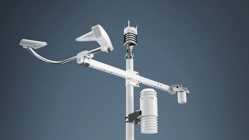
Mobile monitoring realised
Weather and road condition monitoring on the move has become a commercial reality in the form of a new system launched by
According to Vaisala’s global roads marketing manager Jon Tarleton, Vaisala has been able to measure road temperature and other meteorlogical parameters at traffic speed for around 10 years. But now an array of sensors, software and communication technology has formed a complete mobile weather monitoring system.
Recorded data is stored on the vehicle for later download, or communicated via smartphone connection for live weather and road condition monitoring. “The result can be agencies’ existing vehicles becoming mobile measuring units transmiting data to a monitoring service hosted for clients,” says Tarleton. The US has been chosen for initial launch of Condition Patrol, “because North America is slightly ahead in mobile collection technology”. But the plan is to extend the products and service to Europe.
“We now offer a complete weather monitoring system with determination of the thickness of layers of ice, water and snow, and critically, the coefficient of friction of road surfaces,” says Tarleton. “Fixed sensors are extremely accurate, but the number of monitoring stations agencies can practically locate is limited. Customers benefit most by using both. Mobile data collection is less expensive to deploy, highly versatile and gives a view of conditions along a whole route.”
Sensors helping set safe speeds
Climate monitoring technology specialist
Lufft’s NIRS sensors are part of the company’s UMB (universal management bus) modular weather systems with standard communications protocols. “All sensors of the UMB family are completely interoperable with each other. The UMB protocol is proprietary in principle, but well documented and open to customers and OEM partners,” says Lufft senior consultant Karl Schedler.
The Lufft NIRS can be fixed in place as standalone devices or with other equipment and combinations of sensors for weather monitoring, or they can be integrated with systems of active traffic management (ATM) to allow early warning of hazardous road conditions. In one case, along a stretch of the A5 autobahn in the Baden-Wurttemberg region in southwest Germany, 11 NIRS31 sensors mounted on ATM gantries are measuring water film thickness, road temperature and ‘slippperyness’ for controlling variable speed limits in accordance with weather and road conditions.