Lisbon in Portugal is embarking upon a major shift away from city-centre car use to other means of transport. But it will take some planning, according to The Mobility Hubs Design Guide, a handbook for creating better bus connections.
One of the biggest challenges that Lisbon - Europe’s second oldest capital after Athens - faces in terms of mobility is to reduce motor traffic in the city centre. However, city officials believe it must be done. The guide notes that the latest census data for Lisbon shows around 48% of residents from other municipalities who regularly commute to Lisbon for work or study do so by car. Meanwhile, 73% of Lisbon residents use a car for their regular trips outside the city.
The European Commission has set very ambitious goals that the municipality must meet as a signatory of the Covenant of Mayors for Climate and Energy. These goals include halving the use of conventionally-fuelled cars in urban transport by 2030, phasing them out in cities by 2050 and achieving essentially CO₂-free city logistics in major urban centres by 2030.
Integrated mobility plan
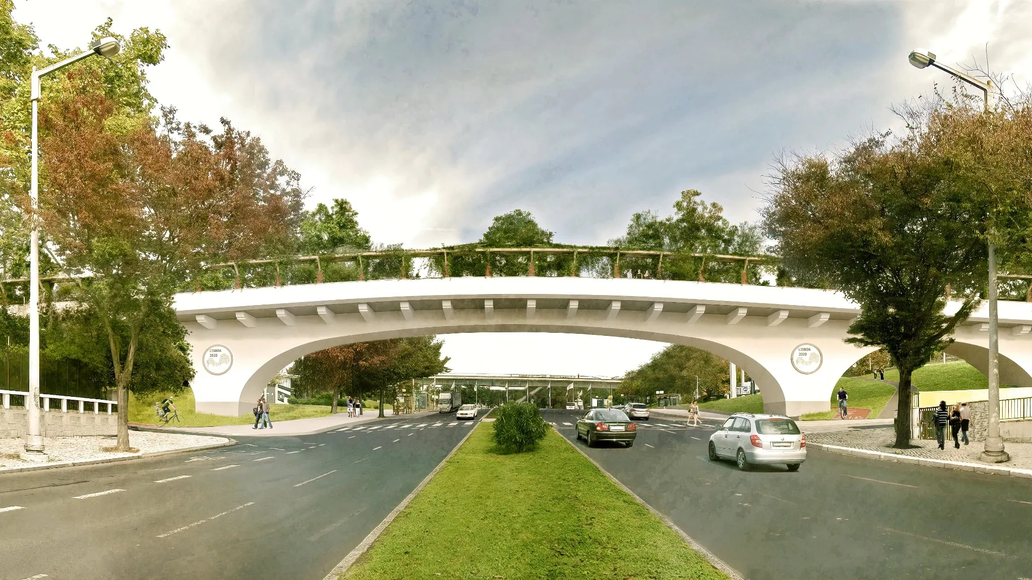
Better cycle-path connections are part of the plan for the city with a population of more than half a million, to get more people out of their vehicles. To this end, Lisbon has started construction of a new “green” cycle-pedestrian bridge over a major city-centre road as part of the Portuguese capital’s integrated mobility plan.
Work on the bridge over Avenue Almirante Gago Coutinho will cost around €2.5 million and it should be open by the end of 2024. The plan is to allow greater connections between three green corridors, namely the central corridor and the Olivais and the eastern corridors of the city, also integrating the existing network of pedestrian and cycling paths, promoting connections to other areas, and in particular bus depots.

According to a report in the local newspaper Lisbon for People, the bridge will have vegetation, shrubs and trees, especially along a central strip – green belt - that separates cyclists from pedestrians, each having a 2.2m-wide path. The green strip will continue over the bridge to dovetail with the green areas that the bridge will connect.
Work on the 105m-long bridge is being led by Emel, Lisbon’s own municipal company for mobility and parking. The new bridge will replace an old structure on the site and provide a level connection between existing nearby cycle paths, some of which are being revamped under a special grant.
Last June, Lisbon received $400,000 from the BICI Program - Bloomberg Initiative for Cycling Infrastructure to improve school connections through active mobility and the connectivity of the city's cycling network. The goal is to connect 20 schools and 20,000 students through safe bike lanes. BICI is promoted by Bloomberg Philanthropies and the Global Designing Cities Initiative.
Better user experience
Lisbon also recently embarked on a major public transport redevelopment strategy, Restart - Masterplan for Lisbon’s Multimodal Mobility Hubs project. Coordinated by Lisbon City Council and developed in partnership with Emel, it studies the creation of a network of large mobility hubs in Lisbon by assessing scenarios for retrofitting the bus terminals of Campo Grande, Colégio Militar, Oriente, Pontinha and Sete Rios.
As part of the tactics to redevelop the bus stations, the Mobility Hubs Design Guide was produced after two years of consultation with urban designers and planners, local agencies, engineers and thousands of public comments and suggestions. Its objective is to establish some guidelines, in particular the key elements to be considered in the design and retrofitting of these depots.
“The primary reason cited for choosing individual transport is that people consider the public transport system ineffective in meeting their daily needs,” the guide says. “Only when we are able to offer a better user experience and ensure a high quality of service will we compete with car use.”
The Mobility Hubs Design Guide is free to download here