
Econolite supports crowdsourced traffic data analytics

Users can tailor the solution for specific traffic control needs, firm says. 
By Ben Spencer August 28, 2020 Read time: 2 mins
Econolite broadens capabilities of Centracs Mobility (Source: Econolite)

Econolite has upgraded its cloud-based Centracs Mobility software platform to support crowdsourced traffic data as an additional source of real-time roadway detection.

Econolite says its traffic management software solution provides transportation agencies the flexibility of integrating real-time traffic data for signal performance measurement and optimisation.

The company believes there has been an expected tipping point where crowdsourced traffic data would have the accuracy and coverage of vehicles to be used as a trusted input for signal timing. 

Econolite's chief technology officer Eric Raamot says the widespread availability of mobile connections to vehicles and cellular devices has made overcrowded data a significant source of real-time information. 

“This form of ‘infrastructure-less’ data has already been leveraged for traffic incident reporting, predictive modelling, and travel time estimation, but has not previously been demonstrated to be a viable source of input for signal performance measures or signal optimisation,” he continues. “By feeding this data into Centracs SPM’s cloud-based analytics, we can now take a significant leap forward in real-time signal optimisation and enable our suite of SPM tools for agencies that may not have the prerequisite infrastructure deployed for traditional advance, or per-lane detection.”

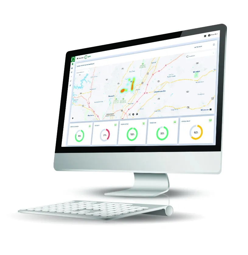
According to Econolite, Centracs SPM is a cloud-based traffic data collection and analytics software system designed to help transportation agencies optimise traffic signal timing. 

Combining Centracs Mobility with SPM's real-time data analytics provides a foundation for aggregating traditional data and real-time crowdsourced traffic data, the company adds.

Econolite is working with research programmes to establish the feasibility to serve many deployments with crowdsourced data. Econolite's software toolset is expected to present signal performance metrics based on toggling the various types of data sources for direct comparison. 


For more information on companies in this article

Related Content

  • Benefits of Florida's traffic signal retiming
    November 7, 2012
    Lee County in Florida has consolidated dramatic results of a major traffic signal retiming with installation of advanced monitoring and management technology for generating further benefits. The Lee County Department of Transportation (DOT), in the US State of Florida, has completed retiming of traffic signals for over 50 intersections in the cities of Fort Myers and Bonita Springs. The project aimed to evaluate existing operations and enable adjustments to optimise flows, and has produced dramatic results
  • Iteris to expand its iPerform data and analytics software solutions
    March 12, 2013
    Intelligent traffic management information solutions provider Iteris is expanding its iPerform traffic and weather-related data and analytics software offering. iPerform was established in 2011 and provides a new generation of intelligent traffic and weather-related information solutions. These solutions bring the power of big data to the prediction of traffic conditions and the delivery of actionable information to both the public and commercial marketplace. The segment’s initial product, IterisPeMS, is a
  • PA Turnpike partners with Waze crowdsourced navigation app
    June 1, 2015
    In an effort to make Pennsylvania’s roads safer and more efficient, the PA Turnpike Commission (PTC) entered a data-sharing partnership with Waze, a real-time, crowdsourced navigation app. Designed as a two-way data share of traffic information, the Waze Connected Citizens Program promotes greater efficiency, deeper insights and safer roads. Users of the app – called “Wazers” – along with other drivers and agencies, like the PTC, collaborate to improve the accuracy, timeliness and availability of roadway
  • Measuring vehicle lengths with a single loop - promising results
    July 27, 2012
    District 7 of Caltrans has been conducting trials to see whether the use of a single inductive loop to measure vehicle lengths and so identify heavy trucks is feasible. So far, the results have been very promising, according to Lead Transportation Engineer Steve Malkson. Between them, the adjoining ports of Los Angeles and Long Beach, the US's two biggest, cover some 10,700 acres (43km2) and 68 miles (109km) of waterfront.