Waycare Tech is implementing its cloud-based mobility platform in collaboration with the Central Ohio Transit Authority (Cota) to increase traffic safety and reduce travel time for residents.
The project is part of the US Department of Transportation Integrated Mobility Innovation Demonstration Research grant of more than $1.7 million awarded to Cota and 13 partners, including the Ohio Department of Transportation (ODoT) and the city of Columbus.
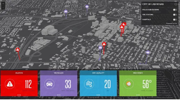
Waycare says its Regional Cloud-Based Traffic Management Artificial Intelligence System allows participating transit agencies, counties and public safety organisations to prepare for and react to real-time traffic information across 13 central Ohio counties on a web-based platform.
Cota CEO Joanna M. Pinkerton says: “This innovative transportation analytics system we are implementing with Waycare and our partners gives all of us access to more powerful information; improving our performance, delivering critical mobility solutions and increasing safety on our roadways.”
The cloud-based technology unifies multiple streams of traffic and transit data to give a real-time view into an area’s traffic patterns, the company adds.
According to Waycare, the system provides insights to predict potential incidents before they occur in order to enhance public transportation effectiveness, expand transit quality, reduce congestion and travel times, increase safety and improve response times to traffic incidents.
Waycare claims the Southern Nevada Regional Transportation Commission (RTC) has reduced its average accident response time by 12 minutes using its platform.
In Central Ohio, when traffic snarls on a Cota transit route, the transit authority and emergency response dispatchers will view ODoT camera feeds of the area through the Waycare platform, giving first responders information about where and what incidents they might encounter.
Meanwhile, Cota can utilise traffic and incident information to re-route its own fleet around those problem areas to help keep its vehicles and customers on schedule.
The system is expected to benefit from Waycare's private sector partnerships such as the bidirectional communication with the Waze app, weather services and connected vehicle technologies.
This information will combine with data from public sources as well as digital video and infrastructure from the 12 additional partners including One Columbus, the Ohio State University and DriveOhio.