City of York Council is to introduce thermal imaging technology on key cycle routes in York to help reduce the time spent at traffic signals, improve journey reliability and cycle safety.
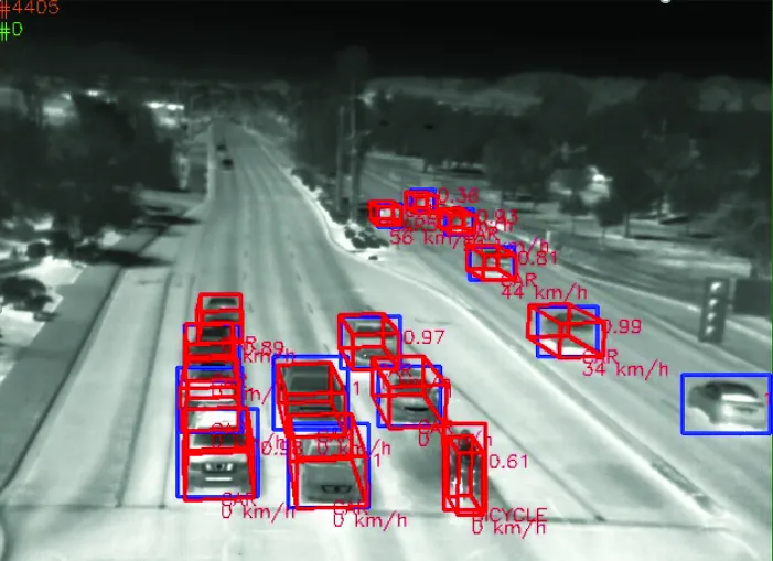
The city is set to become one of the first councils in the country to start using the technology which will accurately detect cyclists at signals by their ‘heat signature’, allowing the signals to react accordingly and be adjusted to give more ‘green time’ for cyclists.
The thermal technology was first introduced by
City of York Council is to introduce thermal imaging technology on key cycle routes in York to help reduce the time spent at traffic signals, improve journey reliability and cycle safety.
The city is set to become one of the first councils in the country to start using the technology which will accurately detect cyclists at signals by their ‘heat signature’, allowing the signals to react accordingly and be adjusted to give more ‘green time’ for cyclists.
The thermal technology was first introduced by1466 Transport for London last year as part of the cycle superhighway network.
The scheme is all part of a multi million pound overhaul of York’s ageing traffic signals – the largest scheme the city has seen since the last major overhaul of York’s traffic signals in the mid 1990s which introduced the city’s new urban traffic control system to control the city’s transport network.
The five year scheme also includes replacement of worn out and unreliable in-road road loops with camera systems for traffic detection.
The authority is also proposing to replace approximately half of the 122 traffic signals and 54 pedestrian crossings in the city over a five-year rolling programme with modern equipment.
The city is set to become one of the first councils in the country to start using the technology which will accurately detect cyclists at signals by their ‘heat signature’, allowing the signals to react accordingly and be adjusted to give more ‘green time’ for cyclists.
The thermal technology was first introduced by
The scheme is all part of a multi million pound overhaul of York’s ageing traffic signals – the largest scheme the city has seen since the last major overhaul of York’s traffic signals in the mid 1990s which introduced the city’s new urban traffic control system to control the city’s transport network.
The five year scheme also includes replacement of worn out and unreliable in-road road loops with camera systems for traffic detection.
The authority is also proposing to replace approximately half of the 122 traffic signals and 54 pedestrian crossings in the city over a five-year rolling programme with modern equipment.