The city of Dublin is using IBM Big Data identify and solve the root causes of traffic congestion in its public transport network throughout the city, which means improved traffic flow and better mobility for commuters. Integrating data from a citywide network of sensors with geospatial data means that city officials are able to better monitor and manage traffic in real time. To keep the city moving, the council’s traffic control centre works together with local transport operators to manage an extensive ne
The city of Dublin is using 62 IBM Big Data identify and solve the root causes of traffic congestion in its public transport network throughout the city, which means improved traffic flow and better mobility for commuters. Integrating data from a citywide network of sensors with geospatial data means that city officials are able to better monitor and manage traffic in real time.
To keep the city moving, the council’s traffic control centre works together with local transport operators to manage an extensive network of roads, tramways and bus lanes.
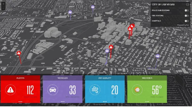
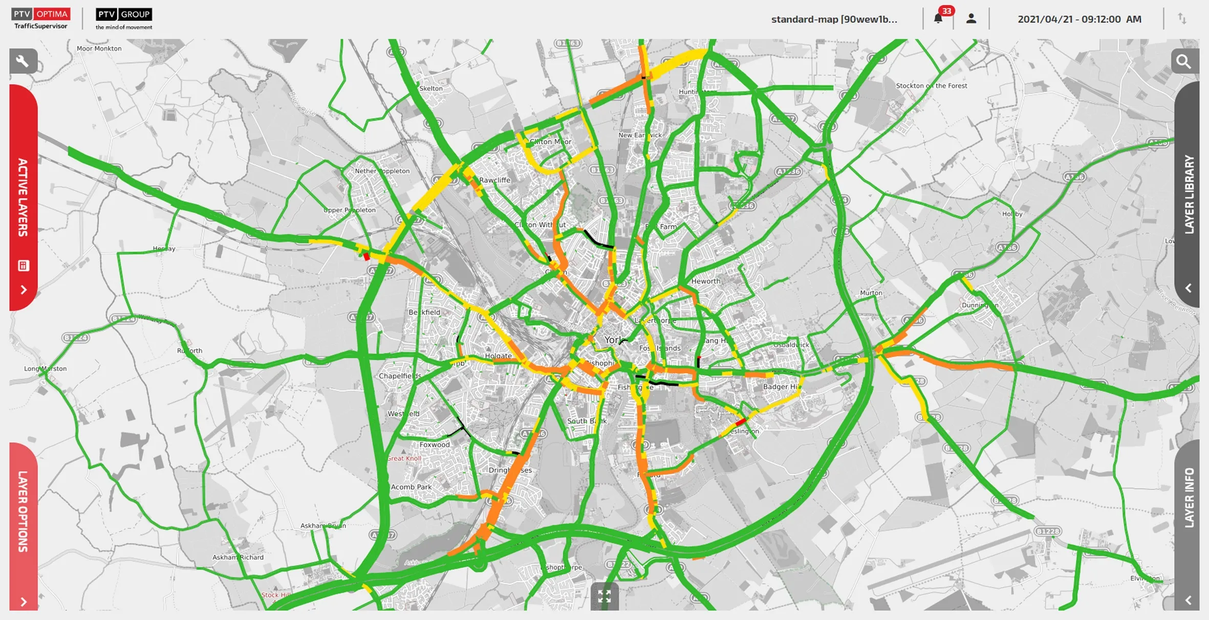
In a collaboration with IBM researchers, its road and traffic department is now able to combine Big Data streaming in from an array of sources – bus timetables, inductive-loop traffic detectors, and closed-circuit television cameras, GPS updates that each of the city’s 1,000 buses transmits every twenty seconds – and build a digital map of the city overlaid with the real-time positions of Dublin’s buses using stream computing and geospatial data.
Traffic controllers can now see the current status of the entire bus network at a glance and rapidly spot and drill down into a detailed visualisation of areas of the network that are experiencing delay giving them an opportunity to identify the cause of the delay as it is emerging and before it moves further downstream.
With improved reporting now in place, the data can help the city identify the optimal traffic-calming measures to reduce congestion. It can also help answer questions such as whether the bus line start times are correct or the best place to add additional bus lanes and bus-only traffic systems.
“Until recently we had a fragmented view of the overall health and real-time status of Dublin’s transport network, making it very difficult to identify traffic congestion in its early stages because the causes of a delay had often moved on,” said Brendan O’Brien, head of technical services, Roads and Traffic Department at7086 Dublin City Council. “As a result of the research collaboration we now have a better idea of how multiple data can be merged from across different sources and the IBM research prototypes show what can be achieved in this area.”
“Constantly in motion, cities generate enormous amounts of data that can help officials deliver a better quality of life for its citizens and build competitive advantage with the right tools,” said Dr. Francesco Calabrese, Research Manager, Smarter Urban Dynamics, IBM Research - Dublin. “Dublin is becoming a smarter city by harnessing Big Data, extracting actionable insights from its transport data and delivering these instantly to decision makers so they can improve traffic flow and awareness of how to prepare for their future transportation need.”
To keep the city moving, the council’s traffic control centre works together with local transport operators to manage an extensive network of roads, tramways and bus lanes.
In a collaboration with IBM researchers, its road and traffic department is now able to combine Big Data streaming in from an array of sources – bus timetables, inductive-loop traffic detectors, and closed-circuit television cameras, GPS updates that each of the city’s 1,000 buses transmits every twenty seconds – and build a digital map of the city overlaid with the real-time positions of Dublin’s buses using stream computing and geospatial data.
Traffic controllers can now see the current status of the entire bus network at a glance and rapidly spot and drill down into a detailed visualisation of areas of the network that are experiencing delay giving them an opportunity to identify the cause of the delay as it is emerging and before it moves further downstream.
With improved reporting now in place, the data can help the city identify the optimal traffic-calming measures to reduce congestion. It can also help answer questions such as whether the bus line start times are correct or the best place to add additional bus lanes and bus-only traffic systems.
“Until recently we had a fragmented view of the overall health and real-time status of Dublin’s transport network, making it very difficult to identify traffic congestion in its early stages because the causes of a delay had often moved on,” said Brendan O’Brien, head of technical services, Roads and Traffic Department at
“Constantly in motion, cities generate enormous amounts of data that can help officials deliver a better quality of life for its citizens and build competitive advantage with the right tools,” said Dr. Francesco Calabrese, Research Manager, Smarter Urban Dynamics, IBM Research - Dublin. “Dublin is becoming a smarter city by harnessing Big Data, extracting actionable insights from its transport data and delivering these instantly to decision makers so they can improve traffic flow and awareness of how to prepare for their future transportation need.”