
EDI project Tech Info aids technicians in the field

June 12, 2013 Read time: 1 min
EDI Project Info QR code

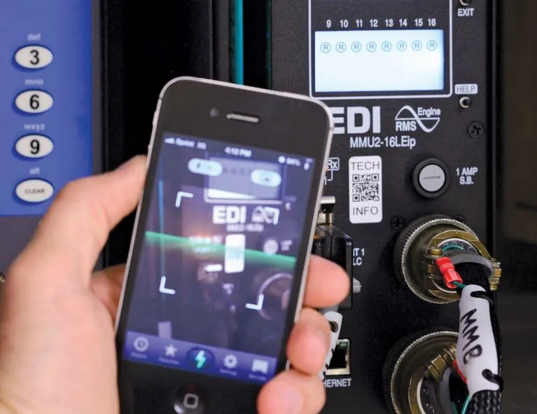
Traffic signal technicians can now scan the QR codes on 41 Eberle Design (EDI) traffic signal control products to quickly retrieve and review vital product information and/or video training.

Project Tech Info utilises QR code scanner apps on Smartphones and tablet computers to retrieve and review product information on the product out in the field.  Users will be directed to the EDI product menu for that model, with a list of available information and documents for the technician to view.

For more information on companies in this article

Related Content

  • Flexible rail ticketing system uses cloud computing
    November 26, 2012
    UK-headquartered IT consultancy firm Smart421 is to design, build and manage a new Live Sales Management system for Rail Settlement Plan (RSP). This system will provide the rail industry with a flexible, high availability cloud-based solution to support ticket on departure - the collection of rail tickets from self service ticket machines after purchasing them earlier on the web.
  • Metro-North seat tracker links to Google Maps 
    December 27, 2021
    Real-time data shows estimated customers in each car on New York MTA rail route
  • Improved zoom camera domes
    February 1, 2012
    Vicon Industries is introducing a new, progressive scan camera within its SurveyorVFT 35X zoom domes. According to the company, the new camera delivers superior video quality in two modes (Normal and High Sensitive); it will be included in all in SurveyorVFT outdoor, impact-resistant and pressurised housings.
  • Cloud computing technology benefits GIS
    July 17, 2012
    Geographic Information Systems are a relatively late adopter of cloud computing,but the benefits of host services for geospatial data and analysis are becoming clear. Jason Barnes reports Both the concept and the reality of cloud computing have been around for some time. More and more industry sectors are entrusting external service providers with the provision of their computing services via the internet. However, the Geographic Information System (GIS) industry has been slow to embrace the trend. This is