Transportation officials in the Dallas area are to introduce an Integrated Corridor Management (ICM) along the 28-mile US 75 from the city to its northern suburbs.
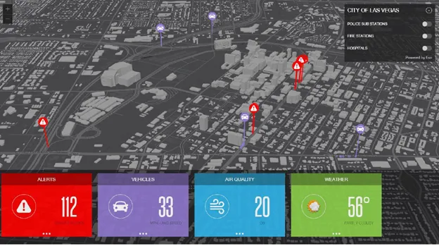
ICM works by collecting data about traffic conditions, then sending it through software that can analyse the data and help operators select the best strategies for managing it. A web interface ensures all the relevant agencies working on the corridor are aware of what is happening. Commuters will be advised of the situation via a new website
Transportation officials in the Dallas area are to introduce an Integrated Corridor Management (ICM) along the 28-mile US 75 from the city to its northern suburbs.
ICM works by collecting data about traffic conditions, then sending it through software that can analyse the data and help operators select the best strategies for managing it. A web interface ensures all the relevant agencies working on the corridor are aware of what is happening. Commuters will be advised of the situation via a new website and electronic signage will also direct drivers to alternate routes in the event of an accident or congestion. The idea is that if traffic on the frontage road is light, officials can take advantage of the capacity that's largely being unused.
"What you're going to experience is a more reliable trip, less congestion and less queuing," says Koorosh Olyai, who led the ICM project while assistant vice president for mobility programs development at1275 Dallas Area Rapid Transit (DART). Olyai now works in the private sector for the firm Stantec, but continues to assist DART on the project.
Dallas was selected by the324 US Department of Transportation as a pilot site for ICM because of its high traffic congestion. US75 is the perfect place to test the concept, given the range of transportation assets along the corridor: a freeway with frontage roads, managed HOV lanes, a tollway, 167 miles of arterial roads, bus routes, a light rail line and 900 traffic signals. The highway itself carries about 250,000 vehicles every weekday.
"All the agencies were really facing a situation where, alone, we'd pretty much done everything we could to make things better," says Robert Saylor, transportation engineering and operations manager with the city of Richardson, a Dallas suburb. "The only way to improve beyond what we're doing would be to do some coordinated actions."
ICM works by collecting data about traffic conditions, then sending it through software that can analyse the data and help operators select the best strategies for managing it. A web interface ensures all the relevant agencies working on the corridor are aware of what is happening. Commuters will be advised of the situation via a new website and electronic signage will also direct drivers to alternate routes in the event of an accident or congestion. The idea is that if traffic on the frontage road is light, officials can take advantage of the capacity that's largely being unused.
"What you're going to experience is a more reliable trip, less congestion and less queuing," says Koorosh Olyai, who led the ICM project while assistant vice president for mobility programs development at
Dallas was selected by the
"All the agencies were really facing a situation where, alone, we'd pretty much done everything we could to make things better," says Robert Saylor, transportation engineering and operations manager with the city of Richardson, a Dallas suburb. "The only way to improve beyond what we're doing would be to do some coordinated actions."