
Baron launches weather condition solution for US DoTs

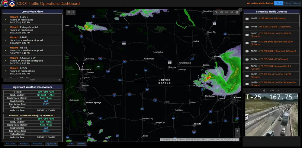
Technology company Baron Weather says its solution can help US Department of Transportation (DoT) services monitor current and forecasted weather conditions. Called Baron Threat Net, the platform also features patented road weather and pavement conditions forecasts. The device comes with a network operations display, mobile app and custom location alerting. In addition, it is intended to integrate a state’s road weather sensor (RWIS) data into a single display. An unnamed US state DoT integrated Threa
June 4, 2018 Read time: 1 min
Technology company Baron Weather says its solution can help 324 US Department of Transportation (DoT) services monitor current and forecasted weather conditions. Called Baron Threat Net, the platform also features patented road weather and pavement conditions forecasts.


The device comes with a network operations display, mobile app and custom location alerting. In addition, it is intended to integrate a state’s road weather sensor (RWIS) data into a single display.

An unnamed US state DoT integrated Threat Net, the solution’s mobile app and Baron custom forecasts for 41 district offices across five regions.

Additionally, Baron's forecasting tools allowed the DoT to monitor and plan ahead for conditions such as winter weather, tropical storms and flash flooding.

Related Content

  • January 14, 2020
    DoTs can benefit from high fibre content
    Existing fibre architecture may be one of the most important assets for DoTs going forward: Skyline’s Paul Lennon explains the importance of evaluating ITS network infrastructure maturity
  • December 19, 2017
    Inrix informs FHWA’s data improvements
    Refinements in the data available from the US Federal Highway Administration will improve road management across America. David Crawford reports. In August 2017, the US Federal Highway Administration (FHWA) issued the first results from an upgraded version of its National Performance Management Research Data Set (NPMRDS). Developed to identify the locations and times of high congestion affecting traffic flows along America’s 259,000km (161,000 mile) national highway system, this is a key resource for sta
  • September 7, 2020
    Esri highlights benefits of a state-wide data-rich environment
    Walk into virtually any traffic operations centre and you will be confronted by people flipping between different screens and CCTV monitors, and individually viewing a large number of stand-alone applications to try to understand a comprehensive picture of their live traffic, weather, incident, and snow conditions from these disparate sources.
  • August 30, 2018
    Lufft launches all-in-one weather sensor for smart city applications
    Lufft says its new all-in-one weather sensor has a temperature accuracy of 1% and can be used to monitor smart city and smart home applications. The device is expected to cover ten measurement parameters simultaneously. The WS10 sensor comes with an integrated compass which enables a direction-independent installation to help it suitable for building management systems, the company adds. WS10 measures temperature, relative humidity, air pressure, wind speed and wind direction, precipitation intensity