Here unveils 3D road models for ADAS and driver safety

Here Technologies has launched Here Lanes with the aim of increasing driver awareness and road safety through advanced driver assistance systems (ADAS).
By Ben Spencer January 21, 2020 Read time: 1 min
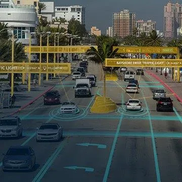
Here Lanes ADAS was launched at CES 2020 (source: Here Technologies)

Here Lanes is a digital representation of the global road network that enables a vehicle to position itself while providing drivers with lane-level visual guidance, the company adds. 

Sheila Nedelcu, head of automated driving at Here, said at CES 2020 in Las Vegas: “Here Lanes delivers automakers and software developers the data they need to improve today’s ADAS functions in all weather conditions while building the next generation of applications supported by lane-level positioning, guidance and visualisation.”  

Here Lanes is expected to feed ADAS and mobile applications with precise lane topology, geometry and attribute data such as the rules of the road, vehicle height restrictions, lane count and centre line, direction of travel and the slope and curvature of intersections. 


Related Content

  • November 23, 2021
    Iteris unveils AI detection solution
    Vantage Apex combines combines FHD video, radar and AI in hybrid traffic solution
  • May 18, 2018
    Joining the dots: four ways to help cities make the connection
    Smoothing the path to connected transportation systems in urban areas all round the world takes a lot of planning: Cisco’s Kyle Connor lays out the four key areas on which he thinks cities should focus. Forward-thinking cities around the world are exploring innovative, new ways to leverage the Internet of Things (IoT) and related technologies to create more connected and efficient transportation systems. Through greater digitisation and connectivity, cities can optimise public transit routes, reduce
  • June 2, 2014
    Machine vision makes progress in traffic applications
    Machine Vision technology is easing the burden on hard-pressed control room staff and overloaded communications networks.
  • May 13, 2016
    Smartphones smooth the journey for visually impaired
    Moves to make life easier and safer for vulnerable and impaired road users are gaining strength on both sides of the Atlantic. A recent webcast by the US Roadway Safety Institute, based at the University of Minnesota, showcased work in progress on a positioning and mapping methodology using Bluetooth and smartphone technologies to support situation awareness and wayfinding for the visually impaired.