Here unveils 3D road models for ADAS and driver safety

Here Technologies has launched Here Lanes with the aim of increasing driver awareness and road safety through advanced driver assistance systems (ADAS).
By Ben Spencer January 21, 2020 Read time: 1 min
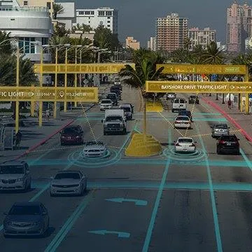
Here Lanes ADAS was launched at CES 2020 (source: Here Technologies)

Here Lanes is a digital representation of the global road network that enables a vehicle to position itself while providing drivers with lane-level visual guidance, the company adds. 

Sheila Nedelcu, head of automated driving at Here, said at CES 2020 in Las Vegas: “Here Lanes delivers automakers and software developers the data they need to improve today’s ADAS functions in all weather conditions while building the next generation of applications supported by lane-level positioning, guidance and visualisation.”  

Here Lanes is expected to feed ADAS and mobile applications with precise lane topology, geometry and attribute data such as the rules of the road, vehicle height restrictions, lane count and centre line, direction of travel and the slope and curvature of intersections. 


For more information on companies in this article

Related Content

  • Moxa launches Full HD IP zoom camera
    March 25, 2014
    Moxa, a global provider of industrial automation solutions, is here at Intertraffic Amsterdam 2014 with a complete portfolio of systematic communication solutions with proven product interoperability and an important product launch – the VPort 56-2MP a Full HD IP zoom camera. The company will demonstrate that progressive video surveillance solutions, including advanced HD IP video cameras with frame rate management, can seamlessly be integrated with fault tolerant, robust Gigabit networks that are planned s
  • Ordnance Survey and Mobileye to deliver roadside infrastructure data in UK
    January 16, 2019
    National mapping agency Ordnance Survey (OS) has joined forces with Mobileye, an Intel company, to deliver high precision road network location data in the UK. OS’ geospatial and technology resources will be paired with Mobileye’s automotive camera-based mapping capabilities to offer a location information service. The partnership, unveiled at Consumer Electronics show 2019 in Las Vegas, also seeks to use the data to support the rollout of connected autonomous vehicles, intelligent mobility and 5G.
  • Overture is open to the bigger picture
    June 18, 2024
    Four of the biggest players in the world of mapping have joined forces to create easy-to-use, interoperable open data that will power the next generation of maps. Kevin Borras talks collaborative interoperability with Overture Map Foundation’s Marc Prioleau and TomTom’s Willem Strijbosch
  • Uber AV driver charged with 'negligent homicide'
    September 17, 2020
    Rafael Vasquez pleads not guilty in collision which killed pedestrian Elaine Herzberg