Here unveils 3D road models for ADAS and driver safety

Here Technologies has launched Here Lanes with the aim of increasing driver awareness and road safety through advanced driver assistance systems (ADAS).
By Ben Spencer January 21, 2020 Read time: 1 min
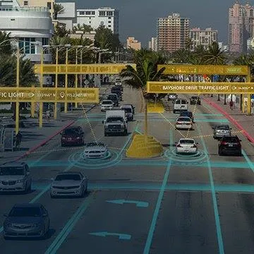
Here Lanes ADAS was launched at CES 2020 (source: Here Technologies)

Here Lanes is a digital representation of the global road network that enables a vehicle to position itself while providing drivers with lane-level visual guidance, the company adds. 

Sheila Nedelcu, head of automated driving at Here, said at CES 2020 in Las Vegas: “Here Lanes delivers automakers and software developers the data they need to improve today’s ADAS functions in all weather conditions while building the next generation of applications supported by lane-level positioning, guidance and visualisation.”  

Here Lanes is expected to feed ADAS and mobile applications with precise lane topology, geometry and attribute data such as the rules of the road, vehicle height restrictions, lane count and centre line, direction of travel and the slope and curvature of intersections. 


For more information on companies in this article

Related Content

  • Bluetooth and Wi-Fi offer new options for travel time measurements
    November 20, 2013
    New trials show Bluetooth and Wi-Fi signals can be reliably used for measuring travel times and at a lower cost than an ANPR system, but which is the better proposition depends on many factors. Measuring travel times has traditionally relied automatic number plate (or licence plate) recognition (ANPR/ALPR) cameras capturing the progress of vehicles travelling along a pre-defined route. Such systems also have the benefit of being able to count passing traffic and have become a vital tool in dealing with c
  • Vehicular networking architecture for local road weather services
    August 19, 2015
    The Finnish Meteorological Institute is currently testing two-way delivery of local weather data as Timo Sukuvaara explains. Road weather information is one of the key ways in which ITS can help reduce traffic accidents and fatalities – which is why the Finnish Meteorological Institute (FMI) has long provided road weather services. Now, the CoMoSeF (Cooperative Mobility Services of the Future) project has been developing communication methodologies to deliver road weather services directly to vehicles and g
  • Where is tolling tech taking us?
    September 25, 2019
    From DSRC and RFID to GNSS or smartphones – which technology is ‘best’ for tolls, charging and pricing schemes? In the first of two articles, Josef Czako examines the options
  • ADAS ‘fastest growing sector’ in automotive field
    July 7, 2015
    According to the latest research by RnR Market Research, Advanced Driver Assistance Systems (ADAS) has been one of the fastest-growing sectors in automotive field and is expected to register a CAGR of 32 per cent during 2014-2019. Currently, developed countries in Europe and America have had nearly eight per cent of new vehicles equipped with ADAS, in contrast to about two per cent in emerging markets. It is predicted that over 25 per cent of new vehicles will carry ADAS by 2019 globally. The Global a