Here unveils 3D road models for ADAS and driver safety

Here Technologies has launched Here Lanes with the aim of increasing driver awareness and road safety through advanced driver assistance systems (ADAS).
By Ben Spencer January 21, 2020 Read time: 1 min
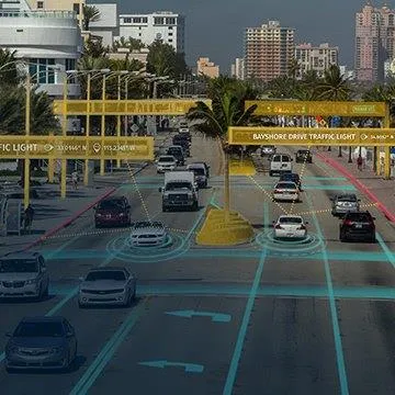
Here Lanes ADAS was launched at CES 2020 (source: Here Technologies)

Here Lanes is a digital representation of the global road network that enables a vehicle to position itself while providing drivers with lane-level visual guidance, the company adds. 

Sheila Nedelcu, head of automated driving at Here, said at CES 2020 in Las Vegas: “Here Lanes delivers automakers and software developers the data they need to improve today’s ADAS functions in all weather conditions while building the next generation of applications supported by lane-level positioning, guidance and visualisation.”  

Here Lanes is expected to feed ADAS and mobile applications with precise lane topology, geometry and attribute data such as the rules of the road, vehicle height restrictions, lane count and centre line, direction of travel and the slope and curvature of intersections. 


For more information on companies in this article

Related Content

  • New constellation will add accuracy and security to GNSS services
    December 20, 2013
    With Galileo’s early services scheduled to start next year, Fiammetta Diani is enthusiastic about the opportunities the EU’s GNSS system will offer. Next year will be a very exciting one for Galileo, the EU’s fledgling satellite constellation; additional satellites are scheduled for launch and, as European Commission Vice President Tajani recently announced, early operational services will be starting towards the end of 2014. So it really is ‘all systems go’ as Fiammetta Diani, market development officer in
  • Calculating the cost of stellar solutions
    August 10, 2016
    The increasing availability and accuracy of global navigation satellite system (GNSS) is opening up low-cost options in many areas as David Crawford finds out. Boosting commercialisation of European global navigation satellite system (EGNSS) technologies for ITS initially depends heavily on demonstrating competitive and cost/benefit advantages obtainable from the deployment of EGNOS (the current European Geostationary Navigation Overlay Service), and ultimately the EU’s Galileo constellation (see box). So,
  • IBTTA: industry must commit to trust and accountability
    August 23, 2018
    Without a commitment to trust and accountability, the modern road tolling industry would not have the bedrock which it requires – and which customers demand, says IBTTA’s Bill Cramer When Tim Stewart, executive director of Colorado’s E-470 Public Highway Authority, settled on ‘trust and accountability’ as the themes for his year as IBTTA president, it was a very deliberate choice. Stewart was looking for language that would help deliver the global tolling industry’s message of service excellence to cust
  • VTT utilises 5G network to improve road safety
    December 12, 2018
    VTT’s Technical Research Centre in Finland has carried out an experiment using the 5G mobile network to help improve road safety, control self-driving cars and assist road maintenance providers. The company says 5G networks and fast data transmission solutions can collect sensor, video and radar data from vehicles. Public funding agency Business Finland subsidised the VTT's 5G-Safe project. It is part of the Challenge Finland competition, an initiative which explores the use of augmented reality an