
SkedGo adds Covid alert to MaaS app

SkedGo’s feature assesses crowd levels to see which routes have fewer people
By David Arminas May 12, 2020 Read time: 2 mins
SkedGo’s latest app feature is designed to make social distancing on public transport easier

Australia-based Mobility as a Service (MaaS) provider SkedGo has launched an occupancy safety-level feature for app developers that also sends out Covid-19 alerts.

The feature assesses crowding levels in order for passengers to see which routes are less crowded when they go to work or visit family, meaning a boost in confidence when choosing public transport, according to the company.

Passengers can choose quieter routes and carriages or switch to alternative forms of transport to maintain social distancing, such as cycling or e-scooters.

This has been trialled using open source data from Transport for New South Wales in Sydney, Australia. It can be rolled out worldwide, depending on data availability, says the company.

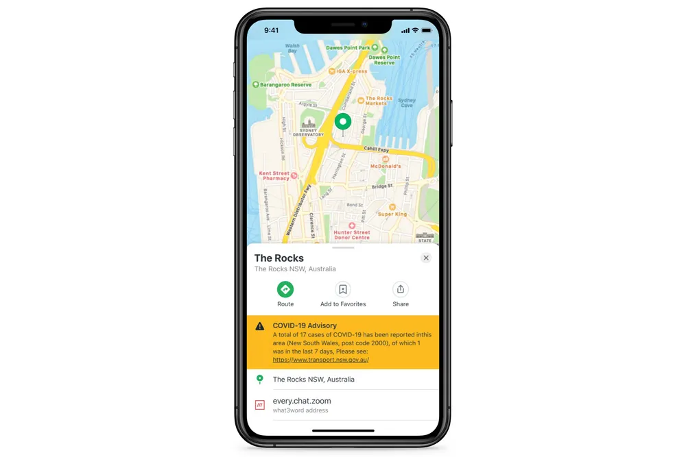
App developers and local transport authorities will also be able share government Covid-19 health alerts through SkedGo’s TripGo API [application programming interface] or SDK [software development kit] tools.

SkedGo’s occupancy feature and Covid-19 alerts use open source data from operators to present real-time information on passenger numbers, arrival times and service information, such as alternative boarding procedures for trains, buses, trams or ferries. In the future, information on cleanliness could also be introduced.

“Transport use is at a record low and recent research has found that 61% of passengers will feel wary using public transport after Covid-19 lockdown measures are lifted,” said John Nuutinen, chief executive of SkedGo.

“We truly believe technology can be a force for good, providing information to reduce the risk of exposure to the virus and protect the safety of all transport users. We are keen to share this tech with any city that can provide occupancy data from its public transport services.”

For more information on companies in this article

Related Content

  • Pandemic ‘proves value’ of emerging world’s informal public transport
    June 9, 2020
    Networks of minibuses fill gaps left by reduced 'formal' services
  • Public transport now on Google maps
    May 15, 2014
    Millions of people rely on public transit to get around and since 2007 Google has worked to include public transit routes and schedules in Google Maps. In its latest blog, Google says it makes it even easier to get around on public transport with the addition of public transport information for Vancouver, Chicago and every 2016 Olympic Games host city in Brazil. David Tattersall, Google’s product manager, Public Transit says in his blog: “Our transit data spans six continents, 64 countries and more th
  • Editor's comment: 'Time to press the re-set button'
    July 13, 2020
    Holistic solutions are required on air quality and inequality - and the ITS industry is involved
  • NSW Government to unlock transport data for app developers
    October 26, 2015
    The New South Wales (NSW) government in Australia is to unlock its public transport data to app developers to create the next generation of real time transport apps for customers. Announcing the move, Minister for Transport and Infrastructure Andrew Constance said, “We’re inviting the app development community to shape a new Open Data Hub, informing how it will work and what kind of data is available to create the apps customers want. “The NSW Government is already a leader in the open data space with