
StreetLight Data provides free VMT metrics

StreetLight Data is offering vehicle miles travelled (VMT) data for US transit agencies to monitor transport networks and understand travel patterns during the Covid-19 pandemic.
By Adam Hill April 17, 2020 Read time: 2 mins
StreetLight Data maps VMT across the US

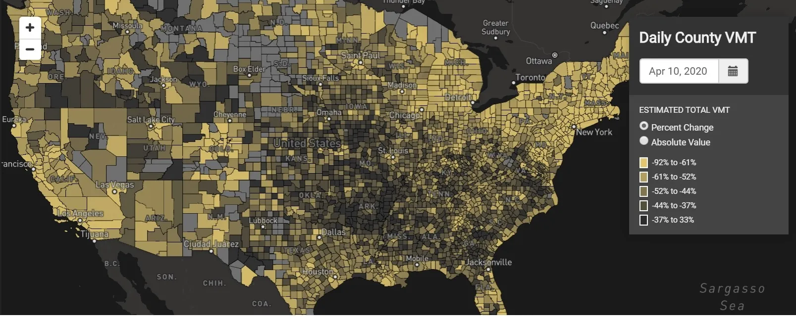
There has been massive disruption to travel patterns since February and Streetlight’s information covers more than 3,100 counties across the US, updated three times a week.

Designed to measure the transportation impact on communities, it is free to planners, researchers and engineers, as well as federal, state and local governments.

"Transportation professionals make critical budget and planning projections based on gas tax revenue and other factors derived from VMT,” explains CEO Laura Schewel.

“The recent massive drop in travel is throwing off all those plans. This data-driven map gets the key metrics out quickly, with local granularity, to those who need them. Planners, like everyone else, are adjusting to a new reality and we’re here to help navigate it. We hope this, in some way, can help our transportation community in this difficult and unprecedented time."

Location intelligence provider Cuebiq is working with StreetLight, and has developed what it calls a ‘near-real time’ mobility index to improve the outbreak forecast and response.

“StreetLight fused Cuebiq’s index with its own algorithms that transform GPS data into contextualised, aggregated and normalised travel patterns, as well as its deep repositories of data depicting historical VMT,” the company said in a statement.

The data is available here.

Related Content

  • December 7, 2020
    Saving the world, one parking space at a time
    Donald Shoup, professor of urban planning at University of California, Los Angeles (UCLA), tells Adam Hill about why parking is too cheap – and how Monopoly could seriously raise its game
  • March 21, 2022
    The benefits of Lidar

    While Lidar is gaining ground in the ITS industry, it has not yet reached the level of mass adoption where it shows up frequently in requests for proposals (RFPs) from cities and DoTs.

  • March 19, 2014
    New opportunities in a data-rich future
    Jason Barnes looks at where the detection and monitoring sector is heading. In the future, there will be no such thing as an un-instrumented road. Just a short time ago, that could have been a quote from a high-level policy document but with the first arrivals of vehicles with 802.11p connectivity – the door-opener to Vehicle-to-X (V2X) applications – it’s a statement which has increasing validity. The technology which uses our roads will also provide information on road conditions but V2X isn’t the only
  • May 26, 2020
    OpenSpace visualises how social distancing will work
    OpenSpace CEO Nicolas Le Glatin tells Adam Hill how Xovis camera tech might help unlock more convenient ways for moving through mobility hubs during Covid-19