StreetLight Data provides free VMT metrics

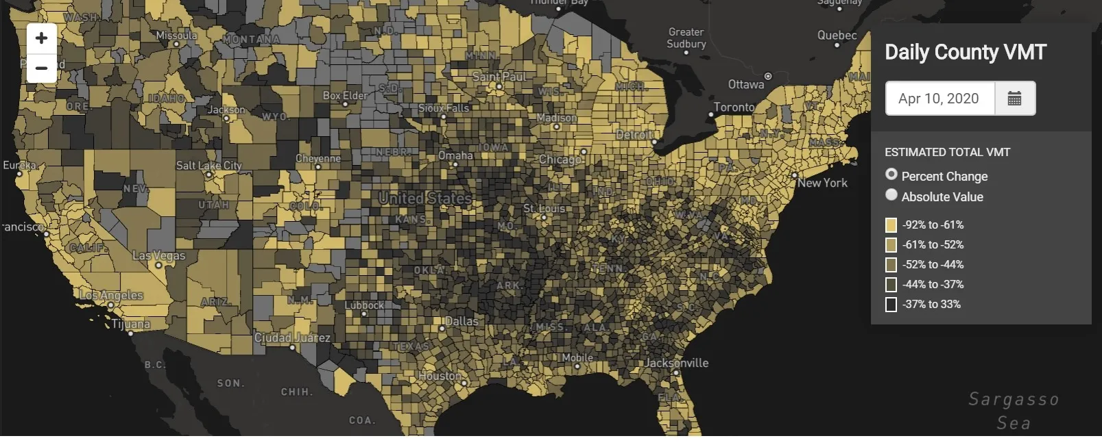
StreetLight Data is offering vehicle miles travelled (VMT) data for US transit agencies to monitor transport networks and understand travel patterns during the Covid-19 pandemic.
By Adam Hill April 17, 2020 Read time: 2 mins
StreetLight Data maps VMT across the US

There has been massive disruption to travel patterns since February and Streetlight’s information covers more than 3,100 counties across the US, updated three times a week.

Designed to measure the transportation impact on communities, it is free to planners, researchers and engineers, as well as federal, state and local governments.

"Transportation professionals make critical budget and planning projections based on gas tax revenue and other factors derived from VMT,” explains CEO Laura Schewel.

“The recent massive drop in travel is throwing off all those plans. This data-driven map gets the key metrics out quickly, with local granularity, to those who need them. Planners, like everyone else, are adjusting to a new reality and we’re here to help navigate it. We hope this, in some way, can help our transportation community in this difficult and unprecedented time."

Location intelligence provider Cuebiq is working with StreetLight, and has developed what it calls a ‘near-real time’ mobility index to improve the outbreak forecast and response.

“StreetLight fused Cuebiq’s index with its own algorithms that transform GPS data into contextualised, aggregated and normalised travel patterns, as well as its deep repositories of data depicting historical VMT,” the company said in a statement.

The data is available here.

Related Content

  • August 22, 2023
    Heavy weather: how ITS can mitigate climate change effects
    Countries, regions and cities all over the world are seeing unprecedented extreme weather events causing destruction in different ways: from heat and wildfires to snow and floods and much else in between. Jon Tarleton of Baron Weather explains how the ITS industry can help the transportation network to remain efficient as the climate changes
  • August 26, 2016
    Vaisala: Weather data is vital for connected vehicles
    Vaisala’s Dr Kevin Petty explains why the weather will continue to play a big part in road safety and traffic management in the smart cities of the future. The world is becoming increasingly connected. Thanks to advances in information and communications technology, the cities we live in are becoming ‘smart’, with everything from education to law enforcement managed by integrated tech solutions in a bid to improve quality of life.
  • January 20, 2012
    Infrastructure spending is an investment in economic recovery
    Transportation funding is caught in the crossfire as the President calls for infrastructure investment and a reinvigorated Republican majority in the House pushes back on federal spending. Andrew Bardin Williams reports. Every few months some politician or pundit declares that the country is on the verge of making the most important political decision in a generation. The 2006 mid-term election; the 2008 Presidential election; the passing of the stimulus bill; healthcare reform; the mania surrounding Tea Pa
  • November 10, 2015
    Benefits of traffic data sharing with app developers
    Timothy Compston finds out if exchanging traffic and road condition data with private app developers makes sense for both drivers and road authorities. Much has been said about the potential benefits for authorities in sharing data with traffic and navigation app developers, and receiving ‘crowdsourced’ information in return – so how is it working in practice?