StreetLight Data provides free VMT metrics

StreetLight Data is offering vehicle miles travelled (VMT) data for US transit agencies to monitor transport networks and understand travel patterns during the Covid-19 pandemic.
By Adam Hill April 17, 2020 Read time: 2 mins
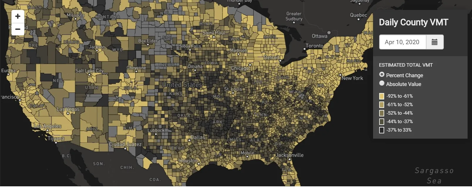
StreetLight Data maps VMT across the US

There has been massive disruption to travel patterns since February and Streetlight’s information covers more than 3,100 counties across the US, updated three times a week.

Designed to measure the transportation impact on communities, it is free to planners, researchers and engineers, as well as federal, state and local governments.

"Transportation professionals make critical budget and planning projections based on gas tax revenue and other factors derived from VMT,” explains CEO Laura Schewel.

“The recent massive drop in travel is throwing off all those plans. This data-driven map gets the key metrics out quickly, with local granularity, to those who need them. Planners, like everyone else, are adjusting to a new reality and we’re here to help navigate it. We hope this, in some way, can help our transportation community in this difficult and unprecedented time."

Location intelligence provider Cuebiq is working with StreetLight, and has developed what it calls a ‘near-real time’ mobility index to improve the outbreak forecast and response.

“StreetLight fused Cuebiq’s index with its own algorithms that transform GPS data into contextualised, aggregated and normalised travel patterns, as well as its deep repositories of data depicting historical VMT,” the company said in a statement.

The data is available here.

Related Content

  • May 4, 2020
    MaaS: 130,000 chances for a bad user experience
    Johan Herrlin, CEO of transit data specialist Ito World, puts himself in the hotseat with ITS International to talk about, among other things, why a beautifully designed MaaS app with a perfect subscription model is still a failure if you get your customers lost along the way
  • April 2, 2014
    Big data and GPS combine to cut emergency response times
    David Crawford looks at technologies for better emergency medical service delivery. Emergency medical services (EMS) play key roles in transporting, or bringing treatment to, patients who become ill through medical emergencies or are injured in road traffic accidents (RTAs). But awareness has been rising steadily, in the US and elsewhere, of the extent to which EMS can generate their own emergencies. The most common cause is vehicles causing or becoming involved in RTAs, as a result of driving fast under pr
  • June 5, 2023
    15-minute cities: Path to dystopia or storm in a side street?
    Urban planners and transportation professionals will need to address wild accusations about the motives behind 15-minute cities - and relevant criticisms too - if the concept is to scale to its potential
  • March 14, 2025
    “Gas tax hasn't gone up since 1993: that's where tolling can come in”
    IBTTA president James Hofmann talks to Adam Hill about new beginnings plus the need for tolling to get the user experience right, streamlining digital experiences - and what to expect from the IBTTA Technology Summit in Dallas