StreetLight Data provides free VMT metrics

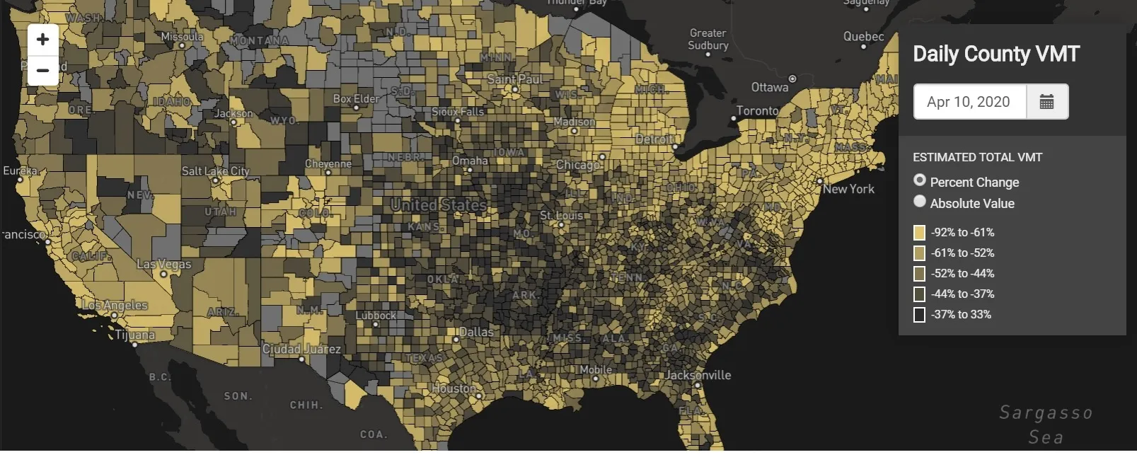
StreetLight Data is offering vehicle miles travelled (VMT) data for US transit agencies to monitor transport networks and understand travel patterns during the Covid-19 pandemic.
By Adam Hill April 17, 2020 Read time: 2 mins
StreetLight Data maps VMT across the US

There has been massive disruption to travel patterns since February and Streetlight’s information covers more than 3,100 counties across the US, updated three times a week.

Designed to measure the transportation impact on communities, it is free to planners, researchers and engineers, as well as federal, state and local governments.

"Transportation professionals make critical budget and planning projections based on gas tax revenue and other factors derived from VMT,” explains CEO Laura Schewel.

“The recent massive drop in travel is throwing off all those plans. This data-driven map gets the key metrics out quickly, with local granularity, to those who need them. Planners, like everyone else, are adjusting to a new reality and we’re here to help navigate it. We hope this, in some way, can help our transportation community in this difficult and unprecedented time."

Location intelligence provider Cuebiq is working with StreetLight, and has developed what it calls a ‘near-real time’ mobility index to improve the outbreak forecast and response.

“StreetLight fused Cuebiq’s index with its own algorithms that transform GPS data into contextualised, aggregated and normalised travel patterns, as well as its deep repositories of data depicting historical VMT,” the company said in a statement.

The data is available here.

Related Content

  • June 17, 2019
    Here’s HD AV map prepared for 5G
    The emergence of 5G may not be necessary to provide a high-definition map for autonomous driving, says Matt Preyss from Here Technologies. Ben Spencer asks why 5G is a hot topic worldwide, with the potential for faster transfer of information eagerly awaited by those convinced that it will be a game-changer for the ITS industry. High-definition (HD) maps are essential to allow autonomous vehicles (AVs) to understand their environment, and operate safely within it in relation to other road users and p
  • June 1, 2016
    TomTom provides flexibility for Riyadh
    With five years of traffic disruption ahead and an inadequate traffic monitoring system, the authorities in Riyadh needed a solution – and quickly. In preparation for embarking on what is currently the world’s largest metro construction project, the Arriyadh Development Authority (ADA) in Riyadh needed to put in place measures to minimise the additional congestion and travel delays the five-year project would inevitably cause.
  • December 21, 2021
    Sharing data creates value - IRF Geneva
    A report on the sharing of data to improve mobility has come up with a policy framework for the industry. Susanna Zammataro, director general of the International Road Federation in Geneva, explains to Adam Hill why this can empower companies and organisations
  • February 19, 2024
    Don’t look at the jigsaw pieces – see the whole puzzle, says CCTA
    There are three main barriers to taking transport ideas from the pilot stage to real-life usage: incompatible technology, local control and limited funding. Tim Haile of California’s Contra Costa Transportation Authority has some thoughts on how to overcome them