StreetLight Data provides free VMT metrics

StreetLight Data is offering vehicle miles travelled (VMT) data for US transit agencies to monitor transport networks and understand travel patterns during the Covid-19 pandemic.
By Adam Hill April 17, 2020 Read time: 2 mins
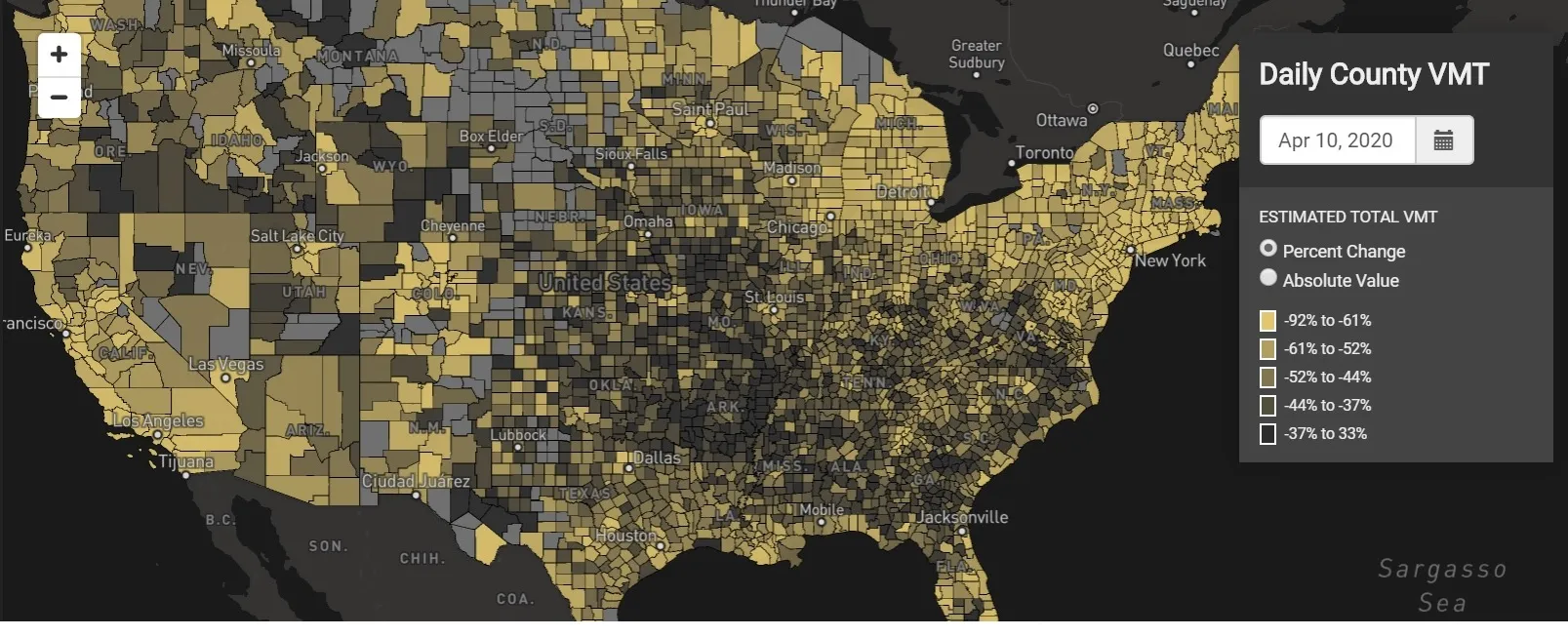
StreetLight Data maps VMT across the US

There has been massive disruption to travel patterns since February and Streetlight’s information covers more than 3,100 counties across the US, updated three times a week.

Designed to measure the transportation impact on communities, it is free to planners, researchers and engineers, as well as federal, state and local governments.

"Transportation professionals make critical budget and planning projections based on gas tax revenue and other factors derived from VMT,” explains CEO Laura Schewel.

“The recent massive drop in travel is throwing off all those plans. This data-driven map gets the key metrics out quickly, with local granularity, to those who need them. Planners, like everyone else, are adjusting to a new reality and we’re here to help navigate it. We hope this, in some way, can help our transportation community in this difficult and unprecedented time."

Location intelligence provider Cuebiq is working with StreetLight, and has developed what it calls a ‘near-real time’ mobility index to improve the outbreak forecast and response.

“StreetLight fused Cuebiq’s index with its own algorithms that transform GPS data into contextualised, aggregated and normalised travel patterns, as well as its deep repositories of data depicting historical VMT,” the company said in a statement.

The data is available here.

For more information on companies in this article

Related Content

  • Xerox’s mobility app offers Mobility as a Service
    June 1, 2016
    Andrew Bardin Williams looks at a new mobility app in Los Angeles and Denver that brings Mobility as a Service one step closer. Commuting today doesn’t have to require a single modal route. You can take Uber to the nearest light-rail station or a bus to the commuter line. Then on the other end of your trip, you can book a bikeshare the rest of the way to your office. For many who live in major metropolitan areas around the US this is a distinct reality as new ways to move from Point A to Point B continue to
  • Time for a rethink on road user charging
    February 1, 2012
    There is no value in further US VMT charging trials, except to delay the inevitable. These trials should end after completion of the University of Iowa's National Evaluation of a Mileage-based Road User Charge. There is far greater promise in unleashing private operators to commence profitable, non-tolling services, then using these for toll assessment and collection as fuel distributors are currently used to collect fuel taxation. Bern Grush writes
  • App informs drivers of delays during Long Beach bridge replacement
    June 6, 2014
    David Crawford previews a work zone travel breakthrough. In February 2014, the Port of Long Beach in California launched what it claims is a groundbreaking construction zone navigation aid - LB Bridge mobile app. The app is designed to help drivers during the Gerald Desmond Bridge replacement programme by keeping them up to date on activity and the ensuing traffic diversions when construction starts in summer 2014. The unusually content-rich app is designed to convey current project news (enlivened by phot
  • Opinion: Have we missed our moment to reinvent mass transport?
    September 16, 2020
    We need to focus on providing better mass transportation services during the COVID-19 pandemic - and work out how to help travellers to rapidly regain confidence in using them as lockdowns end