StreetLight Data provides free VMT metrics

StreetLight Data is offering vehicle miles travelled (VMT) data for US transit agencies to monitor transport networks and understand travel patterns during the Covid-19 pandemic.
By Adam Hill April 17, 2020 Read time: 2 mins
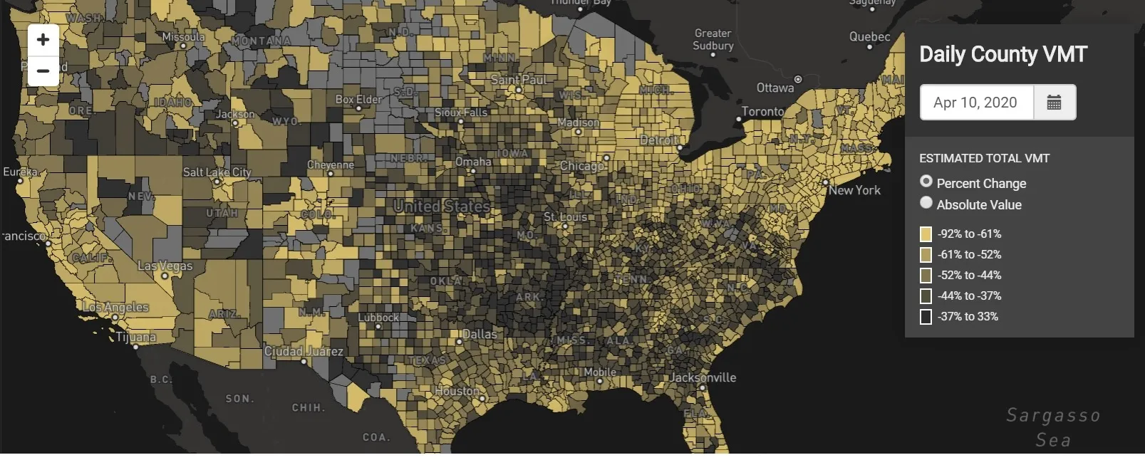
StreetLight Data maps VMT across the US

There has been massive disruption to travel patterns since February and Streetlight’s information covers more than 3,100 counties across the US, updated three times a week.

Designed to measure the transportation impact on communities, it is free to planners, researchers and engineers, as well as federal, state and local governments.

"Transportation professionals make critical budget and planning projections based on gas tax revenue and other factors derived from VMT,” explains CEO Laura Schewel.

“The recent massive drop in travel is throwing off all those plans. This data-driven map gets the key metrics out quickly, with local granularity, to those who need them. Planners, like everyone else, are adjusting to a new reality and we’re here to help navigate it. We hope this, in some way, can help our transportation community in this difficult and unprecedented time."

Location intelligence provider Cuebiq is working with StreetLight, and has developed what it calls a ‘near-real time’ mobility index to improve the outbreak forecast and response.

“StreetLight fused Cuebiq’s index with its own algorithms that transform GPS data into contextualised, aggregated and normalised travel patterns, as well as its deep repositories of data depicting historical VMT,” the company said in a statement.

The data is available here.

For more information on companies in this article

Related Content

  • Toll roads important to Trump’s infrastructure plan
    January 10, 2017
    According to The Hill, US toll roads may surge under a US$1 trillion infrastructure proposal being floated by Donald Trump. The president elect’s idea for rebuilding the nation’s roads and bridges relies on private companies instead of the federal government to back transportation projects. Experts believe this means investors will be attracted to projects that can recoup their investment costs using some sort of revenue stream, such as through tolls or user fees. “If he moves forward with an infrastr
  • Here beats Google as world’s leading location platform, says Ovum
    August 23, 2018
    Here Technologies has toppled Google as the world’s leading location platform, according to a new report. The Dutch mapping company’s price plan appears more developer-friendly and competitive than the Google Maps model, says analyst Ovum. Location Platform Index: Mapping and Navigation ranked 14 major location platform vendors according to their mapping and technology as well as the size of their reach across the developer communities and industries. Here’s Freemium model is intended to lower price
  • Pioneering new passenger information systems
    February 3, 2012
    Chicago pioneers new passenger information initiatives. By David Crawford
  • PTV sets its sights on Smart City solutions
    February 9, 2017
    Making a city smarter not only relies on understand technological opportunities but also human decision-making, as Miller Crockart explains. Cities are about people – a fact that can easily be forgotten when experts talk about roads, healthcare and education as though they are abstract and unconnected monoliths rather than things people use. Understanding how and why people use services is vital for making decisions on how they can be optimised for maximum efficiency across inter-connected networks that for