GeoSLAM showcases 3D mobile mapping for GIS at ESRI User Conference 2017

3D mobile mapping specialist GeoSLAM, a Silver ESRI Business Partner, is participating in the international ESRI User Conference at San Diego Convention Centre on 10-14 July to demonstrate its live digital 3D modelling capability.
July 10, 2017 Read time: 1 min

3D mobile mapping specialist GeoSLAM, a Silver 50 ESRI Business Partner, is participating in the international ESRI User Conference at San Diego Convention Centre on 10-14 July to demonstrate its live digital 3D modelling capability.

GeoSLAM will be scanning the exhibition hall and the Convention Centre using its handheld laser scanning solution, the ZEB-REVO and turning it into a live digital 3D model, to show how the ZEB REVO enables users to rapidly generate and integrate 3D models into their ArcGIS workflows. The system is already in use around the world in a variety of industries such as facilities and asset management, forestry, mining, surveying and engineering.

GeoSLAM will be working with the ESRI Team at the ESRI 3D Island stand in the main hall of the Convention Center, providing live demonstrations of the handheld, mobile surveying system and showcasing how quickly and easily the captured 3D data can be imported into and used in ESRI’s ArcGIS and CityEngine software.

For more information on companies in this article

Related Content

  • Esri highlights benefits of a state-wide data-rich environment
    September 7, 2020
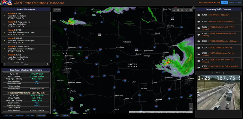
    Walk into virtually any traffic operations centre and you will be confronted by people flipping between different screens and CCTV monitors, and individually viewing a large number of stand-alone applications to try to understand a comprehensive picture of their live traffic, weather, incident, and snow conditions from these disparate sources.
  • ITS World Congress 2012 highlights connectivity
    April 10, 2012
    Vienna is gearing up towards the ITS World Congress, taking place from the 22-26 October 2012. Martin Russ, managing director of AustriaTech, the local organiser, takes a look at how the event is shaping up so far This autumn, Vienna will see a flurry of visitors arriving for the 19th Intelligent Transport Systems (ITS) World Congress. From 22- 26 October, prominent locations in the ‘best city in the world’ (Mercer Quality of Living Survey in 2009, 2010, and 2011) will hold the Congress, hosted by the BMVIT
  • GIS mapping of road-related assets can pay dividends
    June 6, 2014
    Map-based computerised road asset management can pay dividends as Colin Sowman discovers.
  • 3D roundabout analysis and design webcast
    April 26, 2012
    On 16th May 2012, Savoy will be joining with TRL, Autodesk and Design Pro Software to give a live demonstration of the revolutionary BIM workflow for roundabout design that allows simultaneous design and analysis in 3D. It is claimed the new workflow is many times faster than traditional methods and allows users to assess multiple design alternatives very quickly leading to better designs, quicker and cheaper.