PTV provides precise data on Paris traffic

GPS location of vehicles travelling around French capital will be used to ease congestion
By David Arminas July 31, 2023 Read time: 2 mins
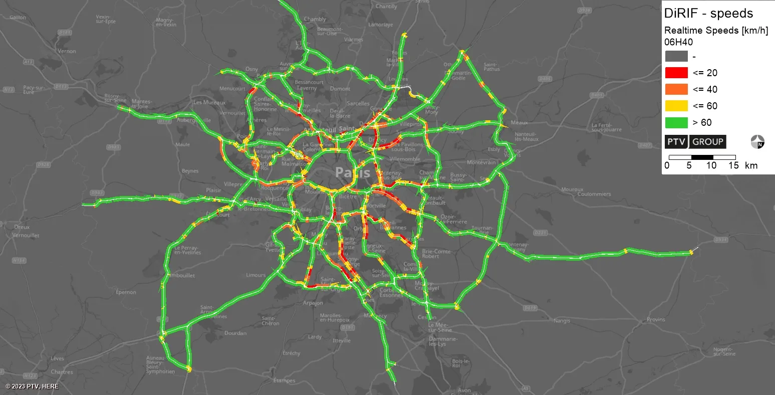
Real-time speeds: floating car data is used by PTV’s real-time software to generate real-time information that integrates with DiRIF's traffic platform, Sytadin (image: PTV Group)

The Paris region highway authority has adopted PTV technology, including PTV Flows to enhance traffic management such as live traffic updates.

The aim of the contract – following a public invitation to tender - is to supply real-time speed data derived from the GPS location of vehicles travelling on the road network managed by DiRIF - Direction des Routes d'Île-de-France - as well as on certain sections of the Île-de-France region's main road network. The data provided complements and enriches the traffic data available to DiRIF, based on its own detectors.

The Paris metropolitan area has 1,300km of highways used by more than four million travellers on average daily. To address numerous bottlenecks and traffic challenges and provide traffic information to road users, DiRIF is offering the online platform sytadin.fr. To further improve the quality of traffic information and effectively monitor the main road network, DiRIF uses real-time data analytics powered by PTV technology.

DiRIF gathers floating car data (FCD) sourced from TomTom, a Dutch multinational developer of location technology that released its first satellite navigation system in 2004. The data is used by PTV’s real-time software to generate highly accurate real-time information in a four-step process that seamlessly integrates with DiRIF's traffic platform, Sytadin.

PTV says that its comprehensive solution significantly enhances the reliability of live traffic updates, allowing DiRIF to inform road users about current traffic conditions, congestion and road closures across the entire metropolitan Paris region. This is especially important in light of upcoming major international events such as the upcoming 2023 Rugby World Cup in the autumn and the Olympic games next year.

PTV's solution equips DiRIF with the tools to handle the increased demands on the road network effectively, said Frédéric Reutenauer, vice president, southern Europe region for PTV Group, which is part of Umovity. “Precise data not only reduces delays and enhances safety but also improves the overall efficiency of the transportation system."

The real-time data analytics solution provided to DiRIF is part of PTV’s real-time portfolio which also includes PTV Flows, which the group says is a cost-effective and hassle-free SaaS-Tool for real-time-traffic management that was recently released.

For more information on companies in this article

Related Content

  • Here and Esri partner on real-time traffic information
    July 9, 2013
    Finland’s Here is to provide its real-time traffic information to GIS mapping software specialist Esri, enabling the company to enhance its web and cloud location platform with more precise location data for intelligent routing with Here Traffic. Here’s traffic information will complement its map content, which Esri has been using for a decade, enabling Esri to provide a location-based analytics offering that will help businesses make more informed decisions. Fleet operators will be able to better manage pr
  • Inrix expands into Brazil
    June 6, 2012
    Inrix, a leading provider of traffic information and driver services announced an exclusive partnership with MapLink, a leading provider of traffic and location-based services in Brazil. “Traffic congestion is one of Brazil’s biggest problems because the country’s infrastructure has not kept pace with its rapid economic growth,” said Inrix senior VP of business development Kush Parikh. “It’s come to a point where gridlock on the country’s roads is stalling further economic growth at a time when they can lea
  • Can GNSS solve the tolling world’s woes?
    December 5, 2013
    Kapsch’s Arno Klamminger and Wolfgang Fleischer consider the need for an agnostic approach to technology for charging and tolling. Periodically, given the march of technology, it is worth pausing and taking stock of where we have got to and where we go next. Such reflections are necessary if we are to take full advantage of what we have at our disposal and, potentially, avoid decisions which push us down technological culs de sac. A look at the use of Global Navigation Satellite System (GNSS)-based technol
  • TomTom to provide Uber with maps and traffic data
    November 16, 2015
    TomTom has signed a global, multi-year agreement to provide maps and traffic data for the Uber driver app. TomTom’s advanced map-making technology, combined with its world class traffic information, will ensure Uber has a seamless navigation experience, accurate arrival times and efficient journeys in more than 300 cities around the world. “We are excited to provide Uber with our best-in-class location data.” said Charles Cautley, managing director maps and licensing at TomTom. “TomTom is a truly in