Teledyne positions itself with Ladybug6

Camera captures 360° images from moving platforms for HD mapping and asset inspection
By Adam Hill February 21, 2023 Read time: 1 min
Ladybug6: 360° view

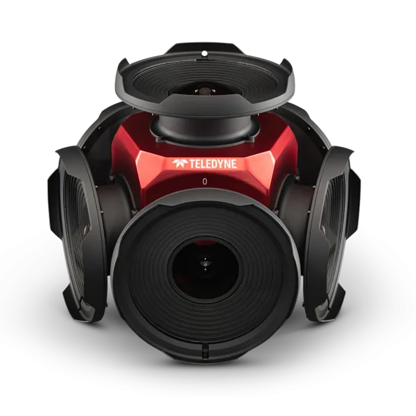
Teledyne Flir is now shipping its new Ladybug6 camera for high accuracy 360° spherical image capture.

The high-resolution unit is designed to capture images from moving platforms in all weather conditions. Applications include panoramic street image production, road and asset inspections, and feature extraction for HD map generation.

Mike Lee, senior product manager at Teledyne Flir, says: “For applications that require high accuracy imaging like high-definition mapping, road surveying and asset inspection, the Ladybug6 gives users precision trigger control and resolution in a field-proven format.”

The manufacturer says support for Global Navigation Satellite Systems (GNSS) and advanced APIs, combined with hardware inputs, enable precise camera settings and trigger control.

Ladybug6's industrial-grade design and out-of-the-box factory calibration produce 72 Megapixel (MP) images with pixel values that are spatially accurate within +/- 2 mm at a 10m distance.

For more information on companies in this article

Related Content

  • Are we nearly there yet? The rise and rise of AI in WiM
    June 4, 2025
    The technology of artificial intelligence has moved on quickly since ITS International last asked the Weigh in Motion community in 2022 - so how is AI used in the WiM sector now? We asked four experts...
  • Radar reinforces detection efficiency
    March 16, 2016
    Radar can have distinct advantages in some transport-related situations as Colin Sowman found out during a visit to Navtech Radar. Despite tremendous advances in machine vision techniques, the accuracy and reliability of camera-based detection systems suffer during periods of poor visibility where other technologies may offer an alternative. Radar is one such technology. It too has seen significant development in recent years and according to Navtech Radar, the technology can often fulfil detection and moni
  • EarthSense Systems reveals cleaner air routes in city-wide project
    October 13, 2017
    A project has been launched to produce city-wide visualisations of air quality through combining EarthSense Systems' (ESS) ordnance survey (OS) geospatial data and real-time air quality data. The technology, a joint venture between Bluesky and University of Leicester, is being used to highlight areas of higher pollution and allows users to identify cleaner air routes such as parks or canal routes. ESS captures measurements on air quality through using a zephyr sensor and a city-wide network of sensors.
  • Here offers data to improve driver safety
    April 27, 2021
    Data from ClearWeather will allow companies to develop software solutions on Here platform