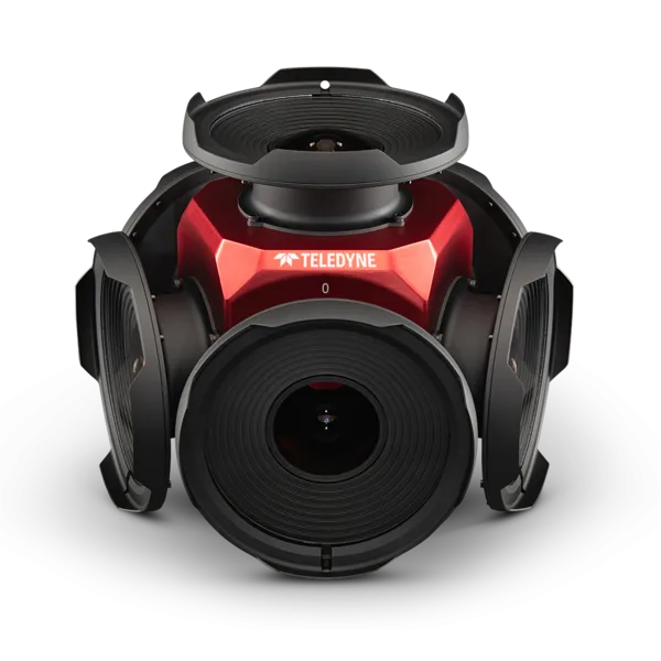
Teledyne positions itself with Ladybug6

Camera captures 360° images from moving platforms for HD mapping and asset inspection
By Adam Hill February 21, 2023 Read time: 1 min
Ladybug6: 360° view

Teledyne Flir is now shipping its new Ladybug6 camera for high accuracy 360° spherical image capture.

The high-resolution unit is designed to capture images from moving platforms in all weather conditions. Applications include panoramic street image production, road and asset inspections, and feature extraction for HD map generation.

Mike Lee, senior product manager at Teledyne Flir, says: “For applications that require high accuracy imaging like high-definition mapping, road surveying and asset inspection, the Ladybug6 gives users precision trigger control and resolution in a field-proven format.”

The manufacturer says support for Global Navigation Satellite Systems (GNSS) and advanced APIs, combined with hardware inputs, enable precise camera settings and trigger control.

Ladybug6's industrial-grade design and out-of-the-box factory calibration produce 72 Megapixel (MP) images with pixel values that are spatially accurate within +/- 2 mm at a 10m distance.

For more information on companies in this article

Related Content

  • IP revolution for CCTV systems yet to happen
    February 3, 2012
    The IP Revolution for CCTV systems which has been predicted for some years now has failed to happen, says Craig Howie, commercial director of Visimetrics Ltd. Given the many aspects of different technologies and standards involved in moving high-value, observation-critical applications into a pure digital age, this is perhaps unsurprising, he feels.
  • Toyota enters partnership to build HD maps for AVs from space
    May 3, 2019
    Toyota Research Institute-Advanced Development (TRI-AD), technology company Maxar Technologies and NTT Data are working together to build high-definition (HD) maps for autonomous vehicles (AV) using satellite imagery. TRI-AD carried out an analysis, saying that current HD maps cover less than 1% of the global road network and there is a need to broaden the coverage of urban areas and local roads before AVs can become a mainstream mobility technology. A HD map created from satellite imagery would all
  • Digital Transformation is the way to comprehensive transportation 
    March 31, 2021
    Transportation worldwide needs to keep up with a variety of challenges: Frederic Giron of Forrester Consulting explains how digital technologies will be the key to making the necessary changes...
  • Intersection monitoring from video using 3D reconstruction
    March 9, 2016
    Researchers Yuting Yang, Camillo Taylor and Daniel Lee have developed a system to turn surveillance cameras into traffic counters. Traffic information can be collected from existing inexpensive roadside cameras but extracting it often entails manual work or costly commercial software. Against this background the Delaware Valley Regional Planning Commission (DVRPC) was looking for an efficient and user-friendly solution to extract traffic information from videos captured from road intersections.