
Tattile part of Genoa bridge warning system 

WiM sensor and camera combination designed to prevent repeat of 2018's fatal collapse
By Adam Hill September 7, 2020 Read time: 2 mins
Tattile's cameras will help Genoa's San Giorgio bridge to remain safe for all users

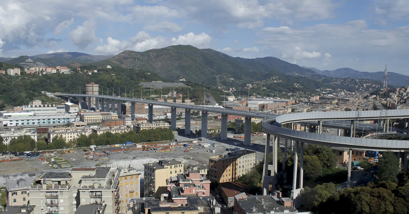
Italian camera specialist Tattile has installed four cameras on Genoa's new San Giorgio Bridge as part of an improved structural monitoring system.

The old Morandi Bridge collapsed in August 2018, killing 43 people.

The new construction includes sensors beneath the platform to detect movements on the road deck, along with the Tattile Vega Basic cameras mounted above the bridge to monitor traffic flow and detect vehicle number plates. 

The idea is that this combination creates an early warning system regarding the bridge's stability and can be used to plan infrastructure maintenance.

The Tattile cameras are connected to a Weigh in Motion system designed by iWIM, which detects and records axle and gross weight of vehicles as they pass over a sensor integrated in durable steel plates on the road surface.

Data from the sensors and cameras is sent to a central server to give a clear picture of what is happening on the bridge at any time. 

Tattile says that while the old bridge was equipped with basic motion sensors under the road to detect movement of the deck, they were not able to trace the causes of the movements.  

"By integrating WiM technology with the combination of Tattile Vega Basic cameras on the new San Giorgio it is now possible to correlate structural deformations to the weight that weighs on the infrastructure, and to trace the weight load caused by individual vehicles crossing it," the company concludes.

For more information on companies in this article

Related Content

  • Inertial sensors dramatically improve GNSS for ITS applications
    January 18, 2012
    Phil Harris, Thales UK, on how fused sensor data can significantly enhance GNSS-based positioning systems' performance in urban areas. Global Navigation Satellite System (GNSS)-based positioning is unique among available positioning technology due to its universal coverage and low equipment cost. By measuring the distances between an unknown position (such as a vehicle), and at least three known positions (GPS satellites), the unknown position can be calculated in three dimensions (latitude, longitude, and
  • New system expedites border crossings
    October 28, 2016
    Enforcing border controls can create long queues for travellers, David Crawford looks at potential solutions. Long delays at border crossings in both North America and Europe have sparked the development of new queue visualisation and management technologies that are cutting hours, even days, off international passenger and freight journeys. At the westernmost end of the 2,019km (1,250 mile) Mexico–US frontier, two parallel crossings between Tijuana, in the former country, and the border city of San Diego,
  • Harnessing the strengths of CMOS for ITS applications
    January 24, 2017
    Sony’s Arnaud Destruels explains the benefits of CMOS sensors for ITS applications. In the transport sector roadside, trackside and platform cameras were devices for viewing and assessing a situation while individual sensors did all the clever stuff like traffic counting, speed calculation, queue lengths, signal status and so on. Well, not any more.
  • Is machine vision the future of enforcement?
    January 25, 2012
    Leading automated enforcement system suppliers talk about how they see machine vision technology affecting the sector in the coming years