Esri and Mobileye offer real-time blind-spot detection data

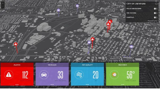
Geographic information system specialist Esri is to collaborate with advanced driver-assistance systems software provider Mobileye in a venture aimed at improving safety for road users in urban environments. This will see Esri’s mapping, analysis and visualisation integrated with Mobileye’s Shield+ product. Shield+ will stream road safety data retrieved from city fleets into Esri’s ArcGIS platform meaning incidents of pedestrians and cyclists being detected in blindspots can be viewed on the Mobileye
November 16, 2017 Read time: 2 mins

Geographic information system specialist 50 Esri is to collaborate with advanced driver-assistance systems software provider 4279 Mobileye in a venture aimed at improving safety for road users in urban environments. This will see Esri’s mapping, analysis and visualisation integrated with Mobileye’s Shield+ product. 

Shield+ will stream road safety data retrieved from city fleets into Esri’s ArcGIS platform meaning incidents of pedestrians and cyclists being detected in blindspots can be viewed on the Mobileye Smart Mobility Dashboard. Shield+ alerts will be updated to the dashboard in real time, providing a city-wide view of pedestrian and cyclist safety.

This will allow users such as municipal bus drivers to receive alerts about imminent hazards seconds before a potential collision, and to have a better, safer awareness of the roads they travel. Mobileye director Nisso Moyal, said the direct uploading of geospatial events from Shield+ fitted to municipal vehicles will enable cities to anticipate and help prevent the next collision and managing their assets more efficiently.

As a part of this collaboration, Mobileye will give municipalities entering into new contracts with it the option to incorporate the analytics-based capability.

Related Content

  • July 11, 2017
    Esri and Here sign multi-year map data licensing agreement
    Esri has signed a multi-year licensing agreement with Here Technologies, which will provide its ArcGIS users with access to global, accurate and fresh geospatial content, including dozens of new and rich map attributes.
  • November 18, 2020
    Esri shows benefits of aggregating multiple data live streams
    The age of connected vehicles is fast becoming a reality. While it brings great promise, it also brings new challenges for those seeking to derive insights from the voluminous data each connected vehicle will transmit. Any number of transportation agencies are beginning to grapple with the challenge of monitoring the live streams of data for traffic management, and ultimately for greater safety of their roadways.
  • March 16, 2016
    Observing driver behaviour in real traffic condition
    The EU’s UDRIVE project will investigate driver behaviour in terms of road safety and the decarbonisation of road transport, as Nicole van Nes and Silvia Curbelo explain. There were nearly 25,700 fatalities on European Union (EU) roads in 2014 or, to look it another way, roughly 70 people are killed in traffic accidents on European roads every day - and many more are injured. Around 22% of the fatalities are pedestrians, 15% will be motorcycle riders and 8% cyclists. So despite the improvements in road safe
  • July 7, 2017
    Bristol’s buses trial CycleEye detection system
    Fusion Processing’s Jim Hutchinson looks at a two-year trial of the company’s cyclist detection system. Is cycling in a city dangerous? Well, that depends where you are and how you view statistics. Malmö is far more bike-friendly than Mumbai and the risk can either be perceived as small - one death per 29 million miles cycled in the UK in 2013 - or large - that equated to 109 deaths in the same year. Whatever your personal take on the data, the effect of these accidents can be felt indirectly too. News of c